


Daytona 500 forecast: Hot, windy race day with strong thunderstorm threat Sunday night
If you're heading to the Daytona 500 at Daytona International Speedway, expect heat and steady winds for the race while the best chance for rain holds off until later. The main concern will come Sunday night when strong to severe thunderstorms are expected to move into Central Florida. Here’s the latest timetable, expected impacts and what fans should keep in mind.
Race-day conditions and timing for storms
Temperatures across the Orlando–Daytona region will climb into the 80s during the afternoon, with a south-southwest breeze sustained around 23–25 mph. Those winds will make it feel warmer and can blow unsecured items around grandstands and tailgate areas.
Most of the heavier precipitation appears likely to arrive after the scheduled on-track activity. The window for the strongest storms is projected between 7 p. m. and midnight ET, with the heaviest rain and thunder developing just after sunset as a cold front moves through the area. The immediate Daytona area should remain dry long enough for the race, but fans leaving the speedway later in the evening should be prepared for rapid weather changes.
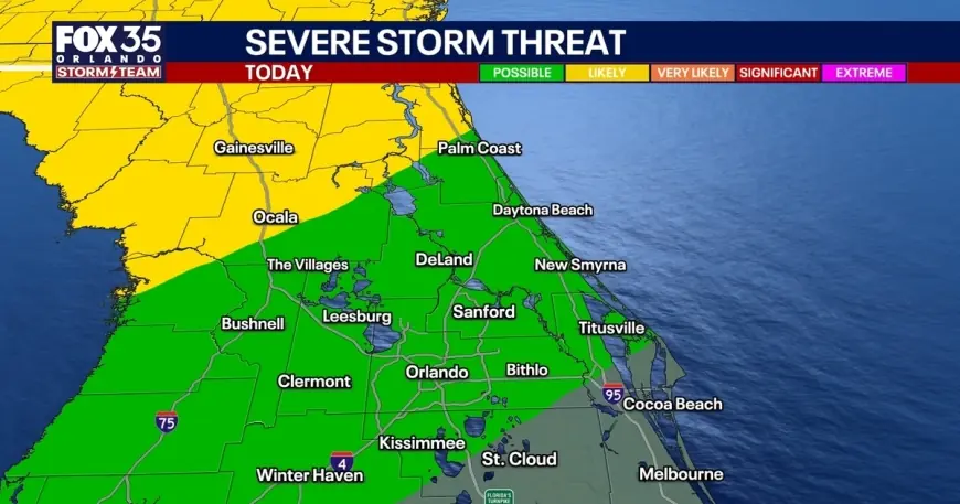
Risk categories for severe thunderstorms vary across Central Florida: the immediate metro area is under a low-end severe risk, locations north of Orlando face a higher threat, and areas south of Orlando are under a marginal risk. These gradations reflect where the atmosphere is most primed for intense storms once the front arrives.
Impacts and safety guidance for fans and residents
The primary hazards with the evening storms will be damaging straight-line winds, heavy downpours that could reduce visibility and lead to localized flooding, and frequent lightning. Forecasters are also keeping a small possibility of an isolated tornado in the threat mix. Expect wind gusts in the 45–55 mph range, with isolated gusts up to 60 mph possible in stronger cells.
Racegoers should secure loose items in campsites and tailgating areas and consider leaving stowed canopies and umbrellas at the track until the threat has passed. If severe weather approaches, move to an interior, sturdy structure and avoid parking under large trees. While at the venue, pay attention to public address announcements and on-site safety instructions; if you’re driving home after sunset, allow extra time and be prepared for heavy rain and gusty winds that can make travel hazardous.
Short-term outlook: cooler Monday, quick warm-up afterward
There is a slim chance of lingering showers early in the workweek, but most of Central Florida should dry out in time for President’s Day. Expect slightly cooler highs Monday in the lower to mid-70s, aided by onshore flow and a bit of upper-level energy that could keep isolated afternoon sprinkles in the forecast.
The cool-down will be brief. A building ridge of high pressure will bring abundant sunshine and a warming trend midweek into next weekend, with afternoon readings climbing into the lower to middle 80s — roughly 10° above average for this time of year. Those planning travel or outdoor activities later in the week should anticipate pleasant, warmer conditions under mostly sunny skies.