


Recent Low Country Earthquakes Echo State’s Violent Seismic History
Recent seismic events in South Carolina’s Lowcountry have stirred memories of the state’s tumultuous seismic history. A pair of minor earthquakes, including a 2.9 magnitude quake, struck near Centerville, south of Charleston, reminding residents of the ongoing threat posed by seismic activity.
Details of Recent Earthquakes
Late on a Saturday night, specifically at 10:37 p.m., the more powerful earthquake occurred at a depth of approximately 3 miles, as reported by the U.S. Geological Survey. This tremor marks the strongest release of energy in the region since August 23, 2025, when a 3.0 magnitude quake impacted the Coronaca area.
Earlier in the same week, a milder 2.3 magnitude quake was recorded near Centerville on February 3. In total, over 800 individuals reported feeling the Saturday earthquake to the USGS, indicative of the tremor’s reach. Minor aftershocks have been detected continuously throughout the week, which likely follow the initial quake.
Impact on the Community
Fortunately, no significant damage or injuries have been reported following these seismic occurrences, according to the South Carolina Emergency Management Division. Despite the lack of major incidents, experts urge residents to remain vigilant and prepared.
South Carolina’s Seismic History
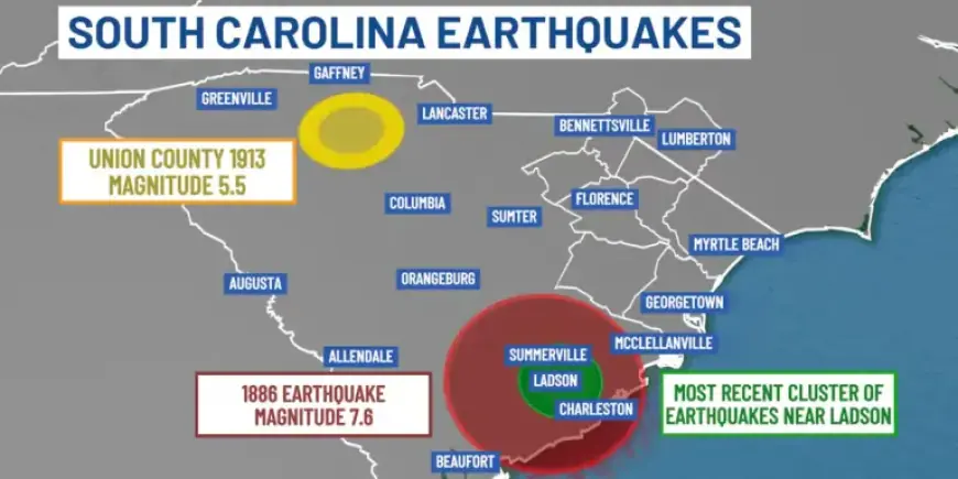
South Carolina has a significant and violent seismic history. Approximately 70% of the state’s earthquakes occur in the Coastal Plain, particularly in zones around Charleston. The most notable event occurred on August 31, 1886, when a devastating magnitude 7.6 quake hit Charleston, killing about 60 people and causing widespread destruction.
Historical Earthquakes in the Region
- 1886 Charleston Earthquake: Magnitude 7.6, 60 fatalities, damage felt up to 200 miles away.
- 1913 Union County Quake: Magnitude 5.5, minimal damage, no deaths reported.
Understanding Earthquake Mechanics
Scientists attribute South Carolina’s intraplate quakes to internal stresses within the North American plate, which reactivates ancient faults. Unlike many global earthquakes that arise at tectonic plate boundaries, these quakes occur within the plate itself.
The South Carolina Geological Survey is actively mapping fault lines and geological features to enhance public understanding of the area’s seismic risks. The concealed faults in the Coastal Plain are challenging to detect due to layers of sediment.
Future Predictions and Preparedness
Despite advances in geological studies, accurately predicting the timing and location of future earthquakes remains elusive. Residents are advised to be aware of the potential for significant seismic events within state borders. Seismic hazard studies are underway to assess ground responses to earthquakes, which will help mitigate risks to life and property.
Residents are encouraged to subscribe to the U.S. Geological Survey Earthquake Notification Service for updates on seismic activities, allowing them to stay informed and prepared for future events.