


Indiana Travel Advisory Map Update: Dozens of Counties Under Warning or Watch as Extreme Cold and Snow Keep Roads Risky
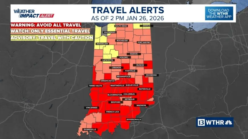
Indiana’s county-by-county travel advisory map remains the key reference point for Hoosiers trying to decide whether it’s safe to drive as the state digs out from a major winter storm and an overlapping burst of dangerous cold. Late Monday, January 26, 2026 (ET), large stretches of central and southern Indiana were still listed under elevated travel statuses, with Marion County among the areas that moved into the most restrictive category before officials signaled a step-down overnight into Tuesday.
At the same time, a statewide disaster emergency declared by Gov. Mike Braun on Saturday, January 24 (ET) continues to shape the response: coordinating state agencies, accelerating resource deployment, and helping local governments manage a multi-day event where “passable” can change hour by hour.
What the Indiana travel advisory levels actually mean
Indiana’s local travel statuses are set by county emergency management and shown on the state map using three levels:
-
Warning (highest level): Travel may be restricted, and residents are directed to avoid roads unless they meet narrow exceptions.
-
Watch: Conditions threaten public safety; only essential travel is recommended.
-
Advisory (lowest level): Travel is hazardous in spots; use caution and avoid problem areas when possible.
A major source of confusion: some neighboring states use “Level 1–3” snow emergencies. Indiana’s system is Warning–Watch–Advisory, and the restrictions attached to each can differ.
Marion County travel advisory and Hamilton County travel advisory: where they stand
As of Monday evening (ET), Marion County was listed under a Travel Warning, and city officials said that status was expected to downgrade to a Travel Watch at 12:00 AM Tuesday, January 27 (ET) if conditions continued improving on primary routes.
Hamilton County was listed under a Travel Watch Monday (ET), with officials urging residents to stay off neighborhood streets where snowpack, drifting, and refreeze can make conditions far worse than what drivers see on major roads.
The practical takeaway: even when a county’s status “improves,” it often reflects progress on primary roads first. Residential streets, cul-de-sacs, bridges, and untreated intersections are usually the last to stabilize.
Indiana road conditions: why “mostly passable” still isn’t a green light
State and local messaging has been consistent: interstates and major highways may be improving, but secondary roads remain uneven. That’s especially true after a heavy event when:
-
plows prioritize arterials and emergency routes,
-
snowbanks limit visibility at intersections,
-
and overnight refreezing turns daytime melt into black ice before the morning commute.
Cold also changes the chemistry. Pre-treatment and salt become less effective as temperatures plunge, meaning roads can look clear but still be slick—particularly on overpasses and shaded stretches.
Indianapolis weather: extreme cold warning raises the risk window
In Indianapolis, the weather itself is now a safety hazard—not just a travel inconvenience. Early Tuesday (ET), the city remained in the grip of frigid air, with a National Weather Service Extreme Cold Warning running from 7:00 PM Monday to 9:00 AM Tuesday (ET) for wind chills that can trigger frostbite quickly.
This matters for drivers because breakdowns and slide-offs become more dangerous: being stuck for even a short period can turn into a medical emergency without proper gear, a charged phone, and a plan.
Indiana state of emergency today: what it changes and what it doesn’t
The statewide disaster emergency declared January 24 (ET) doesn’t “set” county travel statuses—that power sits locally. What it does is widen the operational toolbox:
-
faster coordination across state agencies,
-
easier movement of resources to hardest-hit areas,
-
and a framework that can support federal assistance and logistics flexibility.
Behind the headline, the incentive is simple: officials want fewer cars on the road so plows can work, crashes drop, and emergency responders aren’t delayed. Travel warnings and watches aren’t just about personal safety; they’re about protecting the entire response system from gridlock.
What we still don’t know
Even with the map and advisories, key questions remain unsettled county to county:
-
When residential streets will be fully cleared (not just “drivable”)
-
Whether Tuesday’s daytime warming will meaningfully reduce ice, or simply set up another refreeze Tuesday night
-
How quickly local services—trash pickup, school operations, court schedules—normalize as travel statuses change
What happens next: realistic scenarios for Tuesday (ET)
-
Step-downs from Warning to Watch in areas where main roads stabilize, while rural and neighborhood routes lag.
-
Persistent Watches where drifting and refreezing keep conditions unpredictable.
-
Localized re-upgrades if crashes spike or snow-removal progress stalls.
-
A shift from snow hazards to cold hazards as exposure risk becomes the primary threat through Tuesday morning.
For Hoosiers, the best way to use the Indiana travel advisory map is to treat it as a minimum warning: if your county is at Watch or Warning, assume conditions are worse than they look from your window—especially before sunrise.