


Polar Vortex Alert: Major Stratospheric Shift Predicted for Early February
A significant weather change is anticipated in early February due to a major stratospheric event affecting the Polar Vortex. Recent forecasts indicate a potential full collapse of the Polar Vortex, leading to a surge of Arctic air across North America. This situation arises from a Stratospheric Warming (SSW) event, which is predicted to enhance cold air release, influencing weather patterns throughout February and potentially into early spring.
Polar Vortex Explained
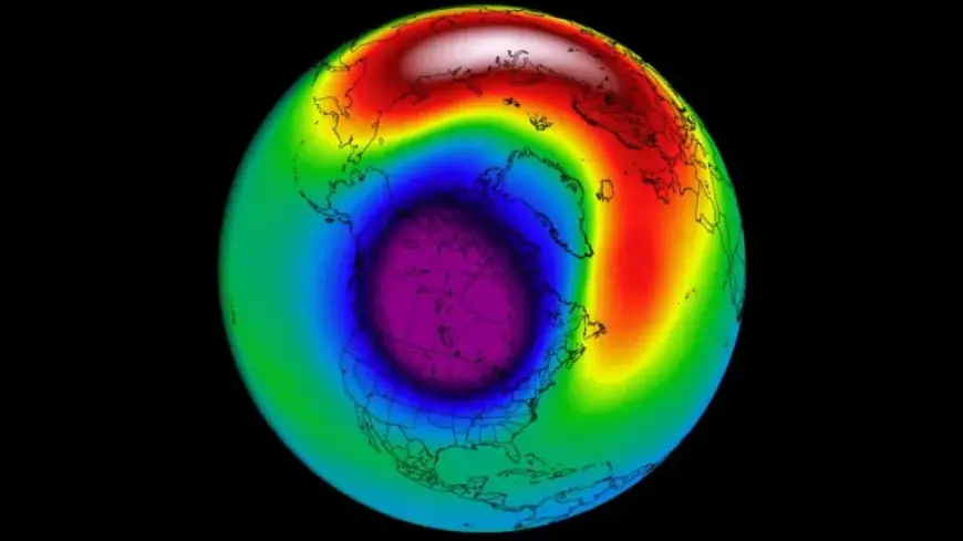
The Polar Vortex is a large area of low pressure and cold air surrounding both the North and South poles. Picture it as a spinning entity that prevents cold air from moving south. When the Polar Vortex is strong, it keeps the frigid air confined to the polar regions, resulting in milder winter conditions over the U.S. and Europe.
Impact of a Disrupted Polar Vortex
A disruption or collapse of the Polar Vortex allows cold Arctic air to flood mid-latitude regions, causing severe winter weather. Current models suggest that this disruption has already commenced, with the Polar Vortex stretching into North America. This condition is ideal for colder temperatures across the U.S. and parts of Europe.
Anticipated Cold Air Release
The latest meteorological data indicates significant cold air movement into southern and eastern Canada, extending into much of the continental United States. Areas of warmer air will remain in the southwest and Florida, but a notable winter storm is expected as the frigid air moves southward.
Stratospheric Warming Event
The Stratospheric Warming event signifies a temperature and pressure rise in the stratosphere, which can destabilize the Polar Vortex. This month, forecasts highlight two high-pressure zones creating intense warming, potentially causing a split in the Polar Vortex and altering the typical winter weather patterns.
Looking Ahead: February Forecast
- Early February may witness a temporary warmer anomaly across the northern U.S. and southern Canada.
- A transitional cold air anomaly is likely to persist through the eastern and southern United States.
- Mid-February forecasts suggest a significant return of cold conditions, with a robust cold air corridor extending from Canada into the United States.
European Weather Patterns
Similar trends are expected in Europe, with colder air returning to northern regions while other parts may experience normal to above-average temperatures. These changes will follow the disruption of the Polar Vortex and are likely to impact weather for weeks following the event.
Stay tuned for ongoing updates as meteorologists monitor the Polar Vortex’s behavior and its implications on global weather patterns this February. For the latest forecasts and insights, visit Filmogaz.com regularly.