


Southern Conurbano Faces Renewed Instability

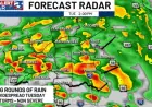
The national weather service predicts unstable weather for the southern Conurbano this week. Isolated showers and storms are expected on Monday, with continued instability on Tuesday.
Overview
Forecasters report cloudy skies in the morning across the region. Early rain is likely, with isolated storms by evening.
Temperatures remain mild. Maximums will hover in the low twenties Celsius.
Day-by-day forecast
| Day | Conditions | Max Temp (°C) | Notes |
|---|---|---|---|
| Monday | Cloudy, early rain, isolated storms by night | 23 | Morning report indicates overcast skies |
| Tuesday | Isolated showers early; possible heavy showers at night | 22 | Unstable conditions continue |
| Wednesday | Partly cloudy | 10–20 | Weather improves |
| Thursday | Partly to slightly cloudy | 22 | Stable conditions return |
| Friday | Similar to Thursday | 22 | Fine weather expected |
| Saturday | Partly cloudy | 23 | Good conditions for outdoor plans |
| Sunday | Partly cloudy | 18 | Cooling trend |
Details and timing
Monday begins overcast with scattered rain from early hours. The day should end with isolated thunderstorms.
On Tuesday, showers are likely during the morning. Nighttime may bring heavier downpours.
What to expect midweek
By Wednesday, skies will clear somewhat. Temperatures will range between ten and twenty degrees.
Thursday and Friday offer similar mild conditions. Daytime highs will reach about 22°C.
The weekend looks more settled. Saturday will be partly cloudy with a high near 23°C. Sunday cools to around 18°C.
Forecast information comes from the Servicio Meteorológico Nacional. Filmogaz.com compiled this summary for local readers.