


Piedmont Triad Faces Frost Risks: Cooler Week Ahead
Meteorologist Lanie Pope issued a forecast update on Apr. 19, 2026 at 10:25 PM EDT. She warned of a much cooler start to the week and frost concerns across the region. Filmogaz.com is reporting the details.
Rainfall, drought and fire danger
Rainfall from the recent front was minimal. Most locations recorded only a few hundredths of an inch. Mountain and foothill totals reached around 0.10 inches in spots near Galax.
Greensboro’s PTI Airport saw no measurable rain in the previous 24 hours. The station sits about two inches below the monthly normal. It is more than four inches below normal for the year. Severe to extreme drought remains in place. The drought outlook may worsen when the next map release arrives on Thursday.
Dry air and gusty winds have raised the fire risk. Officials expect high fire danger to continue through the work week.
Wind and temperature trends
Temperatures fell sharply behind a cold front. Readings dropped roughly 20 to 30 degrees compared with the prior day. Daytime highs returned near seasonal averages.
Observed temperatures included 49 degrees in Reidsville and Danville. Danbury registered 50 degrees and Wilkesboro dropped to 46. Wind gusts ranged from 25 to 35 mph across many areas. Mountain gusts exceeded 40 mph, prompting a wind advisory there.
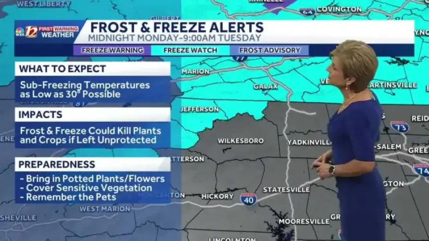
Frost and freeze concerns
The combination of clear skies and lighter winds overnight will allow temperatures to fall. Monday morning lows could reach the upper 30s and low 40s. Patchy frost is possible in the foothills and the Piedmont.
A freeze watch is in effect for the mountains for Tuesday morning. Communities specifically mentioned include:
- Galax
- Hillsville
- Sparta
- Ennice
- Jefferson
- Boone
Freezing readings near or below 32 degrees could damage spring blooms and tender plants. Mountain areas typically see their final frost and freeze in early May. The Piedmont Triad usually reaches that mark by mid April.
Short-term forecast and outlook
Expect mostly dry conditions through the work week. Tuesday will be the coldest morning. Monday’s high should climb into the upper 60s with mainly sunny skies.
Clear skies and northwest winds of 10 to 20 mph will make Monday breezy. Mountain highs will stay in the mid to upper 50s after chilly starts near the upper 30s.
Warmer air building over the central U.S. will arrive midweek. Earth Day, Wednesday, could see highs near 80 degrees. The warmest afternoon now looks to be Friday ahead of an approaching front.
Impacts and recommendations
Gardeners should protect sensitive plants Tuesday morning. Cover or move potted plants indoors when feasible. Those working outside should plan for chilly starts.
Residents should remain cautious about wildfire risk. Avoid open burning until wetter conditions return.
In summary, the Piedmont Triad faces frost risks and a cooler week ahead. Monitor local forecasts and Filmogaz.com for updates.