


Powerful Winter Storm to Bring Heavy Rain, Wind, and Mountain Snow
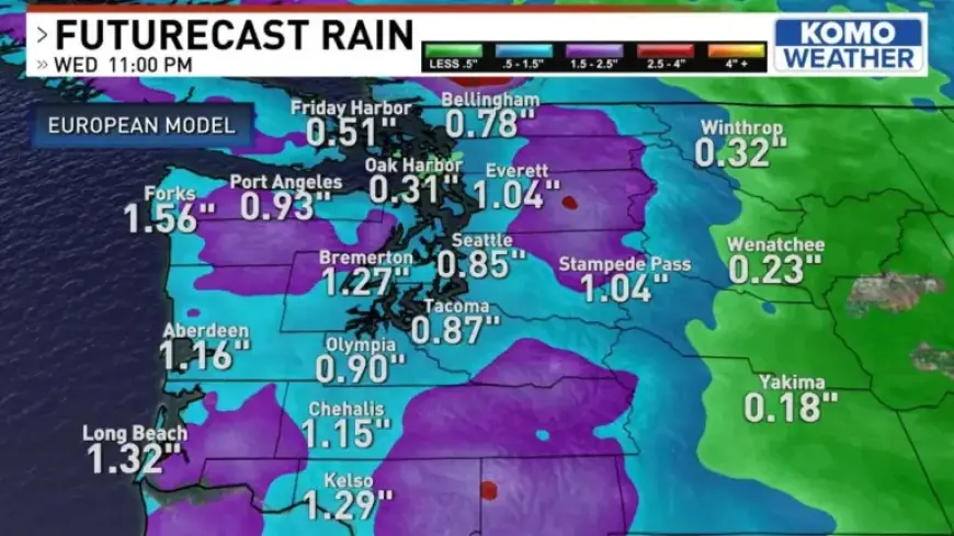
A strong storm system from Alaska will arrive midweek and change the weather. Expect heavy rain, gusty winds, and significant mountain snow. Forecasters say a powerful winter storm is expected to bring heavy rain, wind, and mountain snow across the region.
Overview
The system moves in within about 24 hours. Cold air will follow the leading edge. Snow levels will fall sharply as the storm progresses.
Timeline and forecast
Today and tonight
Light, patchy rain and drizzle linger today. Skies will stay cool, with occasional sunbreaks for some.
Tuesday
Rain spreads into Forks and Port Angeles by morning. Showers build around Seattle, especially north along Interstate 5.
Midday and afternoon turn wet and windy. Gusty southwest winds will be strongest over islands, coastal areas, and open waters.
Mountain snow intensifies above 3,000 feet in the Olympic Mountains and Cascades. Accumulations will rise through the day and evening.
Tuesday night into Wednesday
Rains may begin to break up Tuesday night, while mountain snow continues. Winds should ease somewhat by Wednesday morning.
Snow levels drop from several thousand feet to near or below 1,500 feet. In some spots, levels could fall below 1,000 feet by Wednesday morning.
Expected impacts
Peaks may receive more than a foot of new snow. Some higher summits could see 20 inches or more.
Travel over Stevens and White passes will become slick and hazardous. Snoqualmie Pass could see snow cover by Wednesday morning.
Lower foothill valleys may briefly see snowflakes. Coastal towns will face heavy rain and strong gusts.
Watches and warnings
Forecasters upgraded an earlier watch to a winter storm warning. Residents should prepare for rapidly changing conditions.
After the system moves through, snows will taper by Wednesday evening. The rest of the week looks drier with sunny, chilly mornings.
What to do
- Monitor road conditions before travel, especially mountain passes.
- Secure outdoor items and take precautions for strong winds.
- Prepare for colder nights and frost Thursday morning.
For ongoing updates, check Filmogaz.com and local weather sources. Saturday currently appears favorable, weather permitting.