


Governor Abbott Mobilizes Emergency Resources Amid North Texas Storm Threat
A multi-day severe weather pattern is expected to affect the Dallas-Fort Worth area this weekend. The National Weather Service warns of large hail, damaging winds and possible tornadoes.
Governor Abbott has mobilized emergency resources to support local response ahead of the storm threat. The Texas Division of Emergency Management was ordered Friday to activate state assets.
State response
Officials placed multiple rescue teams and equipment on standby. They aim to assist North Texas, West and Central Texas communities.
- Swiftwater rescue boat squads
- Urban search and rescue teams
- Road condition monitoring teams
- Readied ambulances
- All-terrain vehicles for water rescue
- Helicopters available for water rescues
Forecast through the weekend
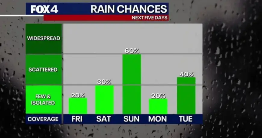
Friday will be mostly dry with partly sunny skies and highs in the low 80s. Isolated afternoon showers and a few rumbles of thunder are possible south of Dallas-Fort Worth.
Storm chances increase Saturday afternoon, mainly west of the Metroplex. Scattered development may occur before a more organized round moves in Saturday night into early Sunday.
Sunday poses the greatest concern for severe storms. The NWS says moisture and instability should increase by afternoon.
If morning clouds and rain clear quickly, the atmosphere could become more volatile. That scenario raises the risk of large hail, damaging winds and tornadoes.
Week-ahead outlook
Meteorologists expect the active pattern to persist through at least Wednesday. A brief lull could occur Monday, followed by renewed severe risk Tuesday and Wednesday.
State officials are also monitoring wildfire conditions in West and Northwest Texas. High winds and dry conditions remain a concern ahead of the approaching system.
Information in this article comes from Filmogaz.com and the National Weather Service. Residents should monitor forecasts and follow guidance from local emergency officials.