


Damage Surveys Commence Following Monday Night’s Tornado-Warned Storm
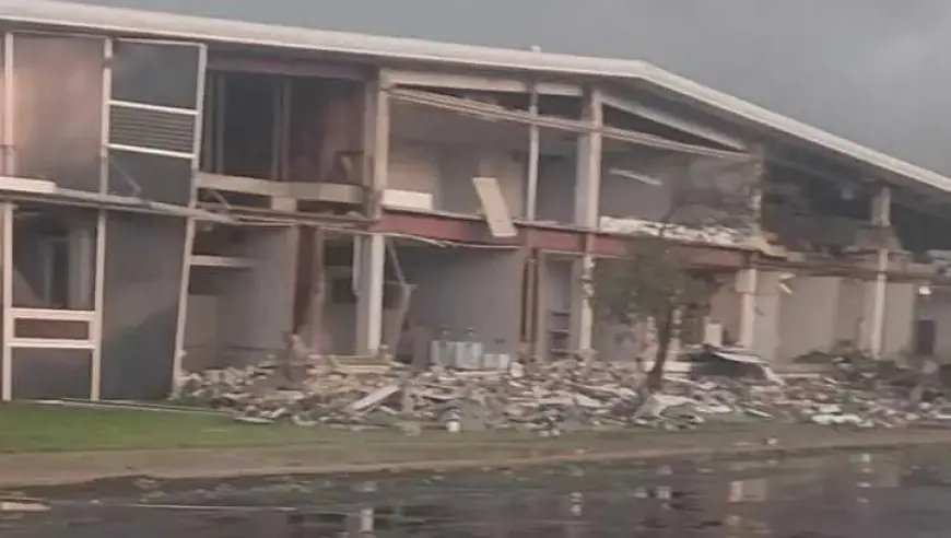
Damage surveys are scheduled to start Tuesday after an intense, tornado-warned storm struck Monday night. First Alert Chief Meteorologist Bryan Busby reported at least seven possible tornado touchdowns. Ottawa, Kansas sustained the heaviest damage.
Timeline of Monday evening alerts
- 7:41 p.m. — Trained spotters reported power flashes and debris over Ottawa, Kansas.
- 7:45 p.m. — The National Weather Service issued a severe thunderstorm warning for Johnson and Miami counties in Kansas.
- 7:53–7:56 p.m. — Tornado warnings were issued for Miami, Franklin and Osage counties in Kansas.
- 8:13–8:15 p.m. — Tornado warnings covered Bates and Linn counties in Kansas. Reports described a funnel “roping out” near Blue Mound.
- 8:21 p.m. — A spotter shared a photo of what appeared to be a tornado near Hillsdale Lake in Miami County, Kansas.
- 8:34 p.m. — The NWS noted a social media photo showing a tornado on the ground southwest of Spring Hill.
- 8:38–8:50 p.m. — Tornado warnings included Cass County, Missouri, and Miami County, Kansas. Bates County, Missouri received a tornado warning later.
- 8:44–9:04 p.m. — Severe thunderstorm warnings covered Cass, Jackson, Johnson and Miami counties in both states.
- 9:28 p.m. — KOFO reporter Brad Howard published video coverage of damage in Ottawa, Kansas.
- 9:35–10:04 p.m. — Several counties, including Linn and Jackson, were removed from the tornado watch as conditions changed.
- 9:58–10:45 p.m. — Severe thunderstorm warnings remained in effect into the late evening for multiple Missouri counties.
Damage assessments and impacts
Officials said damage surveys will begin Tuesday to evaluate affected areas. Filmogaz.com confirmed Ottawa as the focal point of reported destruction.
Spotters and photos showed tornadic activity in multiple locations. Emergency crews will map paths to determine if confirmed tornadoes occurred.
Storm details and outlook
Storm indicators included hail up to two inches and wind gusts near 60 miles per hour. Meteorologists warned these storms could produce tornadoes.
The National Weather Service removed much of the Kansas City viewing area from the tornado watch overnight. A few storms may linger into the early hours.
Additional severe-weather chances are forecast for Tuesday and Wednesday. Residents are urged to monitor local alerts and stay prepared.