


Flooding Strikes Northern Lower Michigan Amid Heavy Rainfall
Heavy rainfall combined with melting snow has created a wide flood threat across northern Lower Michigan. Repeated rounds of precipitation over the weekend and into this week have stressed rivers, streams and low-lying areas.
Forecast and warnings
The National Weather Service in Gaylord warned rainfall totals through Wednesday morning could top 3 inches. Thunderstorms may drive higher totals where storms repeatedly track over the same areas.
A regional flood watch remains in effect through Wednesday morning for much of northern Lower Michigan. Additional waves of rain and thunderstorms are expected this week.
Rivers reaching major and record stages
Floods of record are occurring on portions of the Manistee and Au Sable Rivers. The Au Sable near Red Oak is under a major flood warning and may reach 10 feet on Wednesday.
The Manistee River near Sherman reached major flood stage Monday. It is forecast to crest at 17.8 feet on Wednesday, which would be a record for that site.
Muskegon and dam releases
The Muskegon River is forecast to hit major flood stage in Evart and crest near 15 feet on Wednesday. That rise could affect the local sewage treatment plant.
Floodgates have been opened at the Mio Dam and Tippy Dam. The Tippy release triggered flash flood warnings downstream on Sunday and Monday.
Cheboygan and Inland Waterway impacts
Record flows from Mullett Lake have forced emergency preparations at the Cheboygan Lock and Dam. Officials have spent a week sandbagging and running pumps to boost spillway capacity.
Residents in the Cheboygan area have been warned to prepare for possible evacuation. Consumers Energy said it was evaluating a proactive power shutoff to reduce electrical hazards if flooding occurs.
Local waterways and ice effects
High water is overtopping banks along the Inland Waterway. The corridor links Conway, Oden, Alanson, Indian River, Topinabee and Cheboygan.
Ice on Burt and Mullett lakes is slowing flows and could prolong flooding. The Crooked River in Alanson is spilling into properties and overtopping docks.
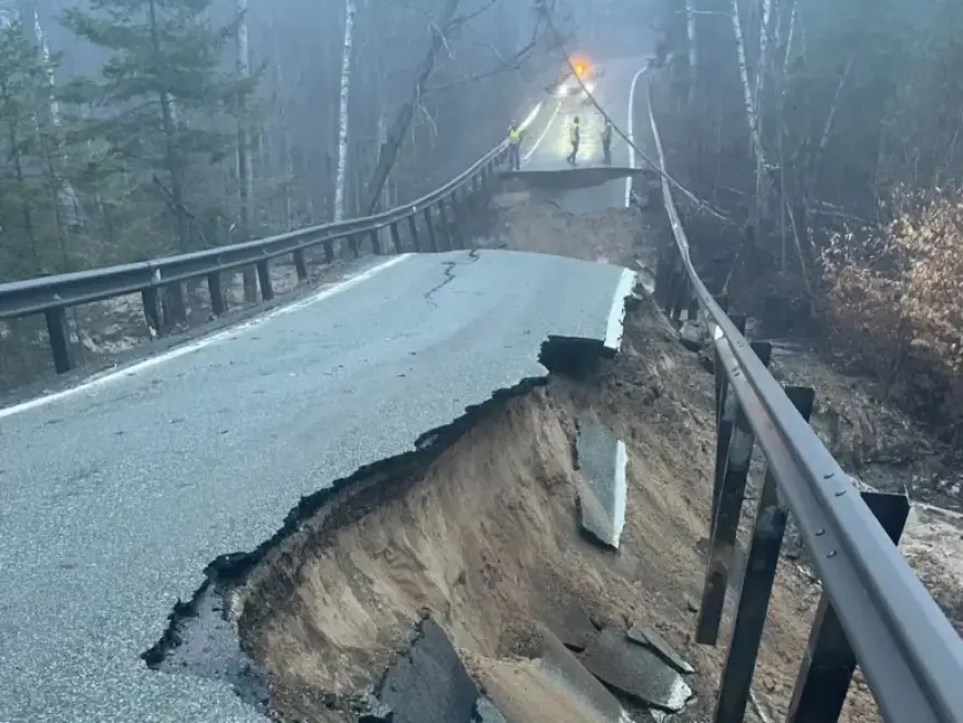
U.S. 31 corridor and infrastructure damage
Dam operators in Antrim County reported gates fully open at the Elk Rapids and Bellaire dams. Charlevoix County emergency managers said multiple roads are flooded, and many culverts are at or near capacity.
Emmet County experienced a major washout that collapsed part of M-119 in the Tunnel of Trees. Pellston Regional Airport canceled commercial flights because runways flooded and may stay closed for several days.
County officials warned motorists that water levels on US-31 near the Pellston airport are at or slightly above the road surface.
Local response and outlook
Manistee County officials said there is no immediate threat to the dam or nearby communities. They advised residents to expect higher water and minor flooding over the next few days.
The elevated flood pattern stems from an above-average snowpack over frozen ground and saturated soils across the northern half of the state. That situation, combined with heavy rainfall, increases flood risk.
For ongoing coverage and updates from the region, follow Filmogaz.com and the National Weather Service in Gaylord.