


Weather Threat: Major East Coast Blizzard Slams NYC, Tri-State Area; Thousands of Flights Canceled
The Weather situation has escalated into a major blizzard that put the entire Tri-State area under a Blizzard Warning through 6 p. m. Monday, bringing heavy snow, high winds and widespread travel disruption that could paralyze the region.
Blizzard warnings, scope and timing
The storm rapidly intensified off the mid-Atlantic coast and is spreading heavy snow and wind from Virginia to New England. The Tri-State viewing area is entirely under a Blizzard Warning through 6 p. m. Monday, with all 29 counties in the viewing area covered — a footprint not seen since the Blizzard of 1996 and with an upper-air setup resembling the Blizzard of 1978. The brunt of the storm unleashed Sunday evening, will continue overnight into Monday morning, and is expected to linger throughout the day, with the potential to paralyze swaths of the region.
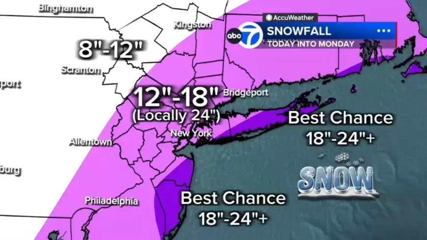
Weather impacts on snow totals and wind
Widespread accumulations of 12 to 18 inches are expected across much of the region, with localized totals of 18 to 24 inches or more in eastern Long Island, the South Shore of Nassau County, parts of the Jersey Shore and even parts of New York City. Farther north and west, for example Pike and Sullivan counties, are forecast to be under 12 inches where the storm's moisture will be less concentrated. Embedded snow bands could produce 2- to 3-inch-per-hour rates; any location trapped under one of these bands for several hours could quickly rack up totals near two feet or more.
Forecasts list wind gusts of 45 to 60 mph, especially along the coast, with 70 mph gusts possible on the East End. The National Weather Service warned gusts up to 55 mph could create whiteout conditions. To meet blizzard criteria, conditions must include gusts over 35 mph, heavy snow, and visibility below a quarter-mile for at least three hours; many places, including Sussex, Poughkeepsie and Newburgh, are likely to meet or exceed that threshold tonight into Monday. Some coastal communities may endure 12 to 16 consecutive hours of blizzard conditions.
Travel chaos and flight disruptions
Travel has already been hit hard. More than 14, 000 U. S. flights had been disrupted as of 5: 30 p. m. ET on Sunday: roughly 8, 858 flights were canceled and about 5, 196 delayed. Major carriers Jetblue, American Airlines, Delta, Southwest and United announced they will waive change and cancellation fees ahead of the storm's impact on Northeast hubs. On the ground, vehicle bans are in place across the Tri-State area and the Long Island Rail Road shut down at 1 a. m., effectively bringing many forms of travel to a standstill.
The National Weather Service cautioned that strong winds with heavy snow will make travel treacherous and potentially life-threatening; whiteout conditions and drifting could compound the disruption.
Coastal flooding, power outages and public safety
Coastal flooding is a major concern, particularly along the South Shore of Long Island and the Jersey Shore, where 2 to 3 feet of inundation is possible in vulnerable back-bay areas during high tide. Heavy, wet snow weighing down trees and wires raises the risk of scattered to numerous power outages. Forecasters warned that the combination of strong winds and heavy wet snow will likely lead to widespread outages.
Health and safety impacts are already being felt: a Tennessee man died after suffering a heart attack while shoveling snow, adding to the storm toll.
Scene reports, official actions and what to expect next
Images from the region show maintenance crews clearing snow from the taxiway at LaGuardia Airport on Jan. 26, 2026, and travelers waiting for flights at John F. Kennedy International Airport on Nov. 18, 2025. More than 40 million Americans are under blizzard warnings, and states of emergency declared in New York and New Jersey have been expanded to include Connecticut, Delaware, Massachusetts and Rhode Island. The nor'easter is forecast to bring 1 to more than 2 feet of snow to parts of the Northeast, with heaviest snow beginning Sunday night and potential totals Sunday night into Monday topping 18–24 inches in New York City, Philadelphia and Boston.
Snow will continue through Monday morning, remaining heavy at times—especially from the city eastward—with conditions finally beginning to ease midday and tapering to lighter bursts late afternoon and evening. Winds are expected to remain strong well into Monday. Could this storm prove to be one for the record books? The situation remains unfolding and impacts will depend on where heavy bands set up and how long communities remain under the most intense conditions.