


Freeze Watch: freeze watch issued for Central Florida as Arctic blast brings dangerous chill
A freeze watch will span Monday night into Tuesday as a sharp blast of Arctic air sweeps over Central Florida, threatening sub-freezing pockets and dangerously low wind chills. The timing matters now for gardeners, pet owners and operators of outdoor attractions facing Monday and Tuesday closures and cold-weather advisories.
Cold front, showers and timing for Sunday into Monday
A cold front moves through Central Florida Sunday, bringing a few scattered showers and even a few downpours before drier air arrives. Temperatures on Sunday are still expected to reach the mid to upper 70s before cooler air settles in later in the afternoon and evening. Showers are forecast to taper off by roughly 1–2 p. m., and after lunch clouds should clear from north to south as breezy, chillier conditions take over.
Gusty winds and Red Flag Warning alongside a Fire Weather Watch
Once the front passes, gusty conditions combined with very low humidity will make wind and drier air the bigger story. Those gusts and low humidity have triggered a Red Flag Warning and a Fire Weather Watch in parts of the area, and officials warn it is not a good time for any outdoor burning.
Cold Weather Advisory and Monday morning lows
Monday morning will bring a cold start, with temperatures in the 30s and 40s and wind chills dropping into the 20s and 30s. A Cold Weather Advisory is in effect from 3 a. m. to 9 a. m. Monday for those dangerously cold feels-like temperatures. Even in the afternoon, highs will only reach the 50s and conditions will remain breezy.
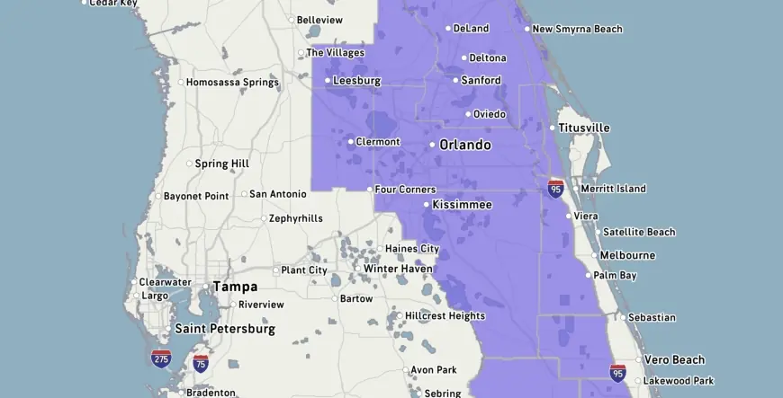
Freeze Watch and Tuesday freeze warning for cities and counties
The Freeze Watch goes into effect Monday night into Tuesday, and a separate freeze warning is in place for Tuesday from 3 a. m. to 9 a. m. The freeze warning covers a large swath of Central Florida and includes the cities of Celebration, Orlando, Kissimmee, Oviedo and Clermont. During the Tuesday freeze watch, sub-freezing readings as low as 30 degrees are possible, and some spots northwest of Orlando could dip below freezing or wake up in the 20s with wind chills in the mid to upper 20s.
Freeze Watches have been issued for several counties, including Marion, Sumter and Flagler, along with locales in Alachua, Levy and Gilchrist counties. Residents are advised to cover plants and bring pets inside as the coldest conditions arrive.
Blizzard Beach closures, repeated water-park shutdowns and the short warmup
Cold conditions are already affecting local attractions: Blizzard Beach water park will be closed on both Monday and Tuesday this coming week, and area water parks have closed a few times so far in 2026 because of the cold. The sharp blast of Arctic air is expected to bring the coldest temperatures of the season and a brief, biting chill before a late-week warmup.
After Tuesday the region should start warming back up by the middle of the week, with a warming trend beginning mid to late week and highs returning to the 80s by Thursday. Forecasters note the cold air will linger through Monday night and Tuesday, with Monday afternoon brighter but still chilly and Monday night into early Tuesday likely the coldest morning of the week with lows in the lower to middle 30s around the metro.
Storm team meteorologist T. J. Springer provided information on February 22, 2026. Michelle joined as a meteorologist in May 2023. Readers were invited to say whether the temperatures will impact their trips on social media. If you need help with the public file, call 291-6000.