


Blizzard Threat Puts Tri-State Residents and Coastal Communities on Immediate Alert as New Jersey State of Emergency Declared
Why this matters now: A Blizzard is poised to hit the Tri-State region starting Sunday, with the heaviest snow overnight into Monday that will first affect coastal communities, commuters and utility infrastructure — and prompted a state of emergency declaration for New Jersey. Officials warn of heavy snow, damaging winds, widespread visibility reductions and coastal flooding that together create a multi-hazard emergency.
Who will feel the Blizzard first and how
Coastal towns, the NYC metro commuter belt and the immediate Jersey Shore are set to see the earliest and sharpest impacts: rain and mixed precipitation this morning will flip to heavy, accumulating snow by midday for New York City and New Jersey, then intensify after lunchtime. Travelers on roads that start the day wet will face rapidly worsening conditions into the evening when heavy bands produce whiteout visibility and rapid accumulation.
Storm mechanics, timing and intensity
The system strengthens as it pulls up the East Coast, combining energy coming from the Ohio Valley with Gulf and ocean moisture to form a coastal storm that closely resembles a winter hurricane. The day begins with scattered light snow and rain across parts of the region; light snow is falling across Sullivan, Ulster, Dutchess, Orange and parts of northwest New Jersey, while most of New Jersey is seeing rain early. Some sleet is mixing in around Ocean County before transitioning to rain.
After lunchtime precipitation will change more widely to snow for New York City and New Jersey. By evening heavier bands will develop and rates will pick up to 1 to 2 inches per hour. Wind gusts near the coast are expected to reach 50 to 60 mph, creating near-zero visibility in places and a widespread risk of downed trees and power lines.
Warnings, local measures and official actions
Every county in the region is under a Blizzard Warning. A Blizzard Warning has also been issued for Philadelphia, several suburban Pennsylvania counties, and for the entirety of New Jersey and Delaware. Gov. Sherrill declared a state of emergency for New Jersey ahead of the winter storm. Westchester County will institute a complete road ban beginning at 9 pm Sunday through 10 am Monday. Drivers are urged to use caution and consider staying off the roads from Sunday evening through Monday morning as snowfall rates pick up.
Definition note: a blizzard means three or more hours of winds gusting to 35 miles an hour or greater combined with falling or blowing snow and visibility less than a 1/4 of a mile. There are no requirements for the amount of snow when it comes to a blizzard.
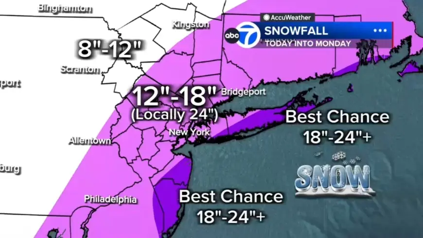
Snow totals, coastal flood risk and who should prepare
- Most of the region: 12 to 18 inches expected.
- Localized 18 to 24 inches in a central corridor from the Jersey Shore to Long Island.
- Best chance for 24-plus inches: East End of Long Island and parts of the Jersey Shore.
- Up to 12 inches farther north and west, including Pike, Sullivan and Ulster counties.
- Coastal flooding: up to 3 feet of coastal inundation possible around high-tide cycles tonight into Monday morning, especially along Long Island and the Jersey Shore.
Morning conditions will feature a light mix and mainly wet roads with visibility issues in spots; afternoon brings the rain-to-snow changeover and increasing snow intensity after lunchtime. Tonight is expected to be the worst period with widespread heavy snow, 1–2 inch per hour rates, 50–60 mph gusts at the coast, blizzard conditions and power outage risk. Monday morning will see heavy snow continue through early morning with improving conditions by mid-morning; snow tapers in the second half of the day though winds remain strong and travel impacted.
Quick Q&A for readers
- Q: Will travel be impossible?
- A: When blizzard conditions develop, travel could be very difficult to impossible as blowing snow significantly reduces visibility. Areas under the road ban and other local restrictions should be avoided.
- Q: When will rain change to snow?
- A: Rain will flip to snow across New York City and New Jersey by midday, with the changeover more complete by evening as temperatures fall.
- Q: Who should expect the largest totals?
- A: Coastal South Jersey, parts of Delaware and the East End of Long Island have the highest potential for heavy accumulations, including localized 18–24 inches and pockets above 24 inches.
Here's the part that matters: the combination of heavy snow rates, very strong coastal gusts and several hours of low visibility creates a scenario where travel, power and coastal properties are all at elevated risk this event.
It’s easy to overlook, but the storm’s resemblance to a winter hurricane—an Ohio Valley energy surge colliding with Gulf and ocean moisture—means coastal flooding and beach erosion risks will accompany snowfall and wind impacts. The timing of the heaviest snow overnight also makes for efficient accumulation and elevated disruption to the morning commute.
The real question now is whether lines of heavier bands produce the highest-end totals in the central corridor from the Jersey Shore to Long Island; confirmation will come as the storm organizes this afternoon and tonight. If you are in the warned areas, finalize plans, charge devices and avoid travel once the evening window begins.