


Weather: Blizzard warnings expanded, snow totals increased for NYC, Tri-State area
The Tri-State region is under threat from a dangerous and potentially historic winter storm that will bring blizzard conditions, heavy snow, damaging winds and coastal flooding, and is expected to intensify rapidly through the afternoon and peak overnight. Weather forecasters say the system could rival the January 2016 storm and will affect travel, power and coastal communities into Monday.
How this storm stacks up: comparisons to January 2016 and rarity since March 2017
The storm is being described as the biggest snow-maker to slam the Tri-State area since the January 2016 storm, which was the largest snowstorm on record for New York City. Meteorologists note the last blizzard warning in the region occurred in March 2017, underscoring how rare this event is. The system forms as energy from the Ohio Valley collides with Gulf and ocean moisture, creating a storm that almost resembles a winter hurricane and is expected to impact Sunday and Monday.
Early conditions across counties and the midday flip to snow in New York City and New Jersey
Morning conditions began with scattered light snow and rain: light snow falling in Sullivan, Ulster, Dutchess and Orange counties and parts of northwest New Jersey, while most of New Jersey saw rain early. Some sleet was mixed in around Ocean County before transitioning to rain. Wet roads this morning may delay initial snow accumulation, and visibility is already reduced in spots with White Plains down to 0. 2 miles. The strengthening coastal storm will pull up the East Coast and tap into enough cold air to flip rain to snow across New York City and New Jersey by midday, with snow becoming more widespread and significantly more intense after lunchtime. Broadway matinee performances with curtain times at 3 pm or earlier will proceed as planned.
Evening and overnight: rapidly deteriorating conditions and blizzard warnings
By evening, heavier bands are expected to develop and conditions will deteriorate rapidly. Forecast details call for snowfall rates of 1 to 2 inches per hour and wind gusts of 50 to 60 mph near the coast, creating near-zero whiteout visibility and a widespread potential for power outages due to downed trees and lines. Every county in the region has been placed under a Blizzard Warning. Tonight is described as the worst period, with widespread heavy snow and the highest risk of outages; heavy snow is expected to continue through early Monday morning with improving conditions by mid-morning and snow tapering in the second half of the day, though strong winds will continue to impact travel.
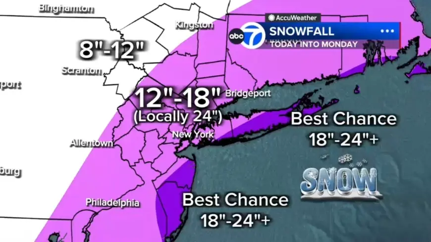
Snow totals, coastal inundation and Weather threat for shore communities
Snow totals are expected to pile up quickly overnight. Forecast ranges include 12 to 18 inches across most of the region, with localized 18 to 24 inches in a central corridor from the Jersey Shore to Long Island. The best chance for 24-plus inches is on the East End of Long Island and parts of the Jersey Shore, while areas north and west such as Pike, Sullivan and Ulster counties may see up to 12 inches. Winds whipping off the ocean will push water inland; up to 3 feet of coastal inundation is possible around high-tide cycles tonight into Monday morning, especially along Long Island and the Jersey Shore.
Travel disruption, flight cancellations, airport activity and storm toll
Thousands of U. S. flights have been canceled as the Northeast rushes to prepare for the intense blizzard expected Sunday. The total number of disrupted flights reached more than 7, 000 as of 6 a. m., with 6, 456 U. S. flights canceled and an additional 547 U. S. flights delayed so far through Tuesday. Jetblue, American Airlines, Delta, Southwest and United have announced they will waive change and cancellation fees. The nor'easter is forecast to bring snow totals of over a foot to parts of the Northeast beginning Sunday, with the heaviest snow beginning Sunday night and potential totals Sunday night into Monday topping 18 to 24 inches in New York City, Philadelphia and Boston. Blizzard warnings are in place for New York City and the New Jersey coastline, while winter storm watches and warnings are in effect for Boston, Philadelphia, Washington, D. C., and Baltimore. Maintenance crews were shown clearing snow from a taxiway at LaGuardia Airport as the major winter storm spread across the United States on Jan. 26, 2026, and travelers were photographed waiting at John F. Kennedy International Airport on Nov. 18, 2025. The storm has also taken a human toll: a Tennessee man died after suffering a heart attack while shoveling snow, adding to the storm's casualties. The National Weather Service warned the storm could create whiteout conditions that will make travel treacherous and potentially life-threatening, and forecasters cautioned that strong winds combined with the weight of heavy, wet snow will likely result in scattered to numerous power outages.