


Blizzard Warning Expanded as Major East Coast Storm Poised to Slam Tri-State Area
A blizzard warning is in effect across the entire Tri-State region as a strengthening coastal storm is expected to intensify through the afternoon and peak overnight, bringing heavy snow, damaging winds and coastal flooding that could make travel nearly impossible. The warning matters now because officials have raised expected totals and taken steps such as announcing a full snow day for New York City public schools.
Blizzard Warning covers every county in the region
Every county in the region is under a Blizzard Warning as a coastal low pulls up the East Coast. The storm’s core is forecast to strengthen this afternoon and peak overnight, producing blizzard conditions including whiteout visibility and widespread power outage potential from downed trees and lines.
Snowfall totals and where the biggest amounts may fall
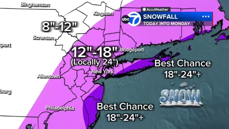
Forecasters have increased expected totals: most of the region is now projected to receive 12 to 18 inches of snow, with a localized central corridor from the Jersey Shore to Long Island likely to pick up 18 to 24 inches. The East End of Long Island and parts of the Jersey Shore have the best chance for 24-plus inches. Areas north and west such as Pike, Sullivan and Ulster counties are expected to see up to 12 inches.
White Plains visibility down to 0. 2 miles; morning conditions
The storm began the day with scattered light snow and rain. Light snow is falling across Sullivan, Ulster, Dutchess, Orange and parts of northwest New Jersey, while much of New Jersey is seeing rain early. There was some sleet mixed in around Ocean County before transitioning to rain. Roads are wet to start, which may delay initial snow accumulation. Visibility is already reduced in spots, with White Plains down to 0. 2 miles, and travel is expected to grow increasingly difficult as heavier snow organizes later today.
Storm mechanics: Ohio Valley energy and ocean moisture
The system involves energy from the Ohio Valley colliding with Gulf and ocean moisture, a setup that forecasters say almost resembles a winter hurricane. That convergence, tapping into just enough cold air, will flip rain to snow across New York City and New Jersey by midday and drive heavy bands after lunchtime. Snowfall rates of 1 to 2 inches per hour are expected in those bands, with wind gusts of 50 to 60 mph possible near the coast.
Coastal flooding threat for Long Island and the Jersey Shore
Winds whipping off the ocean will push water inland, creating a coastal flooding threat around high-tide cycles tonight into Monday morning. Coastal inundation up to 3 feet is possible, especially along Long Island and the Jersey Shore, raising the risk of flooded roadways and additional infrastructure impacts on top of heavy snow and wind.
Timing and public actions: night into Monday
After lunchtime, snow becomes more widespread and significantly more intense. By evening, heavier bands begin developing and conditions will deteriorate rapidly with near-zero visibility and a widespread power outage risk. The worst conditions are expected tonight. Heavy snow is forecast to continue through early Monday morning, with improving conditions by mid-morning and snow tapering in the second half of the day; winds are expected to remain strong and travel will likely stay impacted.
Officials have already announced that New York City public schools will have a full snow day tomorrow, Mayor Mamdani announces. Stay with Eyewitness News for live updates on the storm.
What makes this notable is the storm’s scale and rarity: forecasters say it could be the biggest snow-maker to hit the Tri-State area since the January 2016 event, and the region last faced a blizzard warning in March 2017. The combination of rapid intensification, high snowfall rates, 50–60 mph coastal gusts and potential for up to 3 feet of coastal inundation creates overlapping hazards that will complicate response and recovery.
Residents are advised to prepare for prolonged impacts from heavy snow, strong winds and coastal flooding through Monday as the system moves on.