


Blizzard Warning Expanded as Major East Coast Storm Threatens Tri-State
A widespread blizzard warning is in effect as a strengthening coastal storm moves up the East Coast, threatening the Tri-State area with heavy snow, damaging winds and coastal flooding. The blizzard warning matters now because the system is forecast to intensify through the afternoon and peak overnight, producing rapid snowfall rates and dangerous travel during tonight’s high-tide cycle.
Blizzard Warning Covers Every County
Every county in the region is under a Blizzard Warning as the coastal low strengthens. Forecasters say the system will tap into energy from the Ohio Valley and collide with Gulf and ocean moisture, a combination that has produced a storm described as almost resembling a winter hurricane. That setup is expected to pull up the coast and pull in just enough cold air to flip rain to snow across New York City and New Jersey by midday.
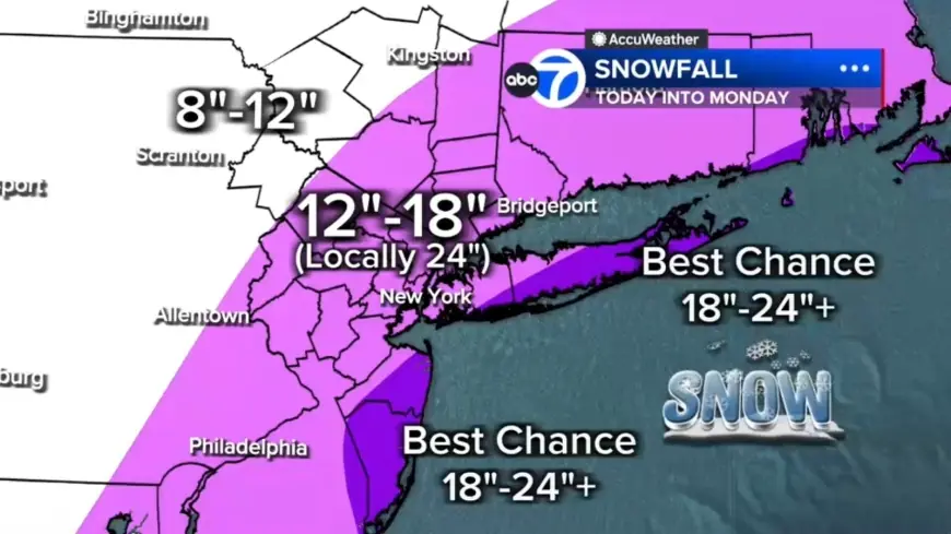
Snow Totals Target NYC, East End of Long Island and Jersey Shore
Accumulations are expected to pile quickly. Forecast ranges outlined for the region include 12 to 18 inches across most areas, with a localized central corridor from the Jersey Shore to Long Island projected for 18 to 24 inches. The best chance for 24-plus inches is on the East End of Long Island and parts of the Jersey Shore. North and west locations such as Pike, Sullivan and Ulster counties could see up to 12 inches.
Whiteout Conditions and Wind: 1 to 2 Inches Per Hour and 50–60 mph Gusts
Heavier bands will likely produce snowfall rates of 1 to 2 inches per hour by evening, with wind gusts of 50 to 60 mph near the coast. Those conditions will create whiteout visibility and raise the potential for widespread power outages due to downed trees and lines. Visibility is already reduced in spots; White Plains has been measured down to 0. 2 miles.
Coastal Flooding Threat Along Long Island and the Jersey Shore
Winds whipping off the ocean will push water inland during tonight’s high tides, creating a coastal flooding threat. Up to 3 feet of coastal inundation is possible around high-tide cycles tonight into Monday morning, with Long Island and the Jersey Shore identified as particularly vulnerable.
Timeline and Local Impact: Rain Turns to Snow, Worst Conditions Tonight, Improvement Monday
The storm’s timing will drive impacts. This morning began with a scattered mix of light snow and rain and wet roads, a condition that may delay initial accumulation but is expected to change quickly. Light snow is falling across Sullivan, Ulster, Dutchess and Orange counties and parts of northwest New Jersey, while most of New Jersey is seeing rain early. Some sleet has mixed in around Ocean County before changing to rain.
By midday the rain-to-snow transition is expected across New York City and New Jersey and, after lunchtime, snow should become more widespread and intense. Evening is forecast to bring the worst conditions: widespread heavy snow, 1 to 2 inches per hour rates, 50 to 60 mph gusts along the coast, near-zero visibility and a heightened risk of power outages. Heavy snow is expected to continue through early Monday morning, with conditions improving by mid-morning and snow tapering in the second half of the day. Even as precipitation eases, winds are expected to remain strong and travel will continue to be impacted.
Westchester County Road Ban and Local Precautions
Local authorities have taken specific measures in response to the threat. Westchester County will institute a complete road ban beginning at 9 pm Sunday and remaining in effect through 10 am Monday. Motorists should expect travel restrictions and clear communications from county officials. Live updates will be necessary as the situation evolves and the storm peaks overnight.
What makes this notable is the comparison to past events: forecasters characterize the system as the most significant snow-maker for the Tri-State area since the January 2016 storm, which remains the largest snowfall on record for New York City, and it marks a rare return to blizzard-warning conditions not seen since March 2017. With heavy snowfall rates, strong coastal gusts and a multi-foot coastal inundation threat all timed around overnight high tides, the combination of factors creates a narrow window in which impacts will intensify rapidly.
Residents in affected counties should prepare for rapidly deteriorating conditions, heed local restrictions such as the Westchester County road ban, and monitor updates as the storm continues to evolve. The blizzard warning will remain a central indicator of immediate risk as the system moves through the region tonight and into Monday.