


Blizzard Threatens Tri-State and Philadelphia as New Jersey Declares Emergency
A Blizzard is expected to strike the Tri-State area and Philadelphia beginning Sunday, bringing heavy snow, damaging winds and coastal flooding that could produce the region’s largest snowfall since 2016. The timing—heaviest snow overnight into Monday—raises the risk of rapid accumulation, whiteout conditions and widespread travel disruption.
Blizzard Warning for Philadelphia, New Jersey and Delaware
Blizzard Warnings have been expanded across the region: every county in the Tri-State area is under a Blizzard Warning, and specific warnings have been issued for Philadelphia, several suburban Pennsylvania counties, the entirety of New Jersey and Delaware. A Blizzard is defined here as three or more hours of winds gusting to 35 miles per hour or greater, falling or blowing snow, and visibility under 1/4 of a mile; there is no minimum snowfall amount required for this designation.
Gov. Sherrill Declares State of Emergency in New Jersey
Governor Sherrill has declared a state of emergency for New Jersey ahead of the storm, mobilizing preparations as the coastal system strengthens. The AccuWeather Alert posted for Sunday into Monday warns of heavy snow, blizzard conditions across most of the area, high winds, coastal flooding and beach erosion.
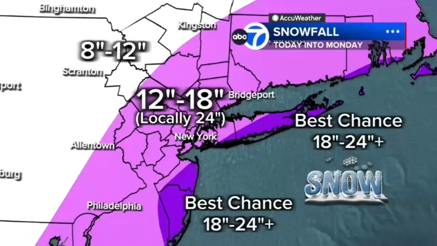
Snow Totals: 12 to 18 Inches for Coastal Areas, Localized Higher Amounts
Forecast totals now call for 12 to 18 inches across most of the region, with a localized 18 to 24-inch corridor stretching from the Jersey Shore to Long Island. The best chance for 24-plus inches is on the East End of Long Island and parts of the Jersey Shore. Areas north and west such as Pike, Sullivan and Ulster counties can expect up to 12 inches.
Coastal Flooding Threat along Long Island and the Jersey Shore
Winds whipping off the ocean are expected to push water inland, creating a coastal flooding threat: up to 3 feet of inundation is possible around high-tide cycles tonight into Monday morning, especially along Long Island and the Jersey Shore. The same onshore winds raise concerns about beach erosion as highlighted in the regional alert.
Early Conditions in New York and New Jersey: Rain, Sleet and Wet Roads
The storm is beginning with scattered light snow and rain. Light snow is reported across Sullivan, Ulster, Dutchess and Orange counties and parts of northwest New Jersey; most of New Jersey is seeing rain early. Some sleet mixed in around Ocean County before transitioning to rain. Wet roads this morning may delay initial accumulation, but the coastal storm will strengthen through the afternoon and flip rain to snow across New York City and New Jersey by midday, with snow intensity increasing after lunchtime.
Wind, Visibility and Power Risks in White Plains and Coastal Areas
Visibility is already reduced in some locations; White Plains has been measured down to 0. 2 miles. By evening, heavier bands are expected to organize and snowfall rates could reach 1 to 2 inches per hour. Near the coast, wind gusts of 50 to 60 mph are possible, producing whiteout visibility and a widespread potential for power outages as downed trees and lines are expected. Gusty winds could also bring down tree branches and produce isolated outages in suburban areas.
Timing, Travel Advisories and Expected Evolution into Monday
Light precipitation should begin Sunday morning in many places, with areas northwest of Philadelphia likely starting with light snow showers. In and around Philadelphia, a mix of rain and snow is expected early, with rain showers south and east; ground temperatures above freezing and air temperatures in the mid-30s mean snow will likely melt initially on contact. Temperatures are forecast to reach about 39 degrees on Sunday before falling late in the day, and as temperatures drop later in the evening precipitation will change over to snow for all areas. The heaviest snow is expected Sunday night into Monday, creating ideal conditions for rapid accumulation; drivers are urged to use caution and consider staying off roads from Sunday evening through Monday morning. By Monday morning snow will begin tapering off from west to east as the coastal storm continues to strengthen and move away, with improving conditions by mid-morning and snow tapering during the second half of the day, although winds will remain strong and travel impacts may persist.
What makes this notable is the storm’s structure: energy from the Ohio Valley colliding with Gulf and ocean moisture is producing a coastal system that taps just enough cold air to behave similarly to a winter hurricane, concentrating heavy bands of snow and wind where coastal and onshore dynamics align. Residents across the Tri-State, Philadelphia and New Jersey are being urged to stay indoors and prepare for rapid, hazardous changes to travel, power and coastal conditions.