


Weather threat: Major East Coast blizzard aims at Tri-State, thousands of flights canceled
A dangerous and potentially historic winter storm is set to slam the Tri-State area later today, bringing blizzard conditions, heavy snow, damaging winds and coastal flooding that will rapidly intensify through the afternoon and peak overnight into Monday. Local broadcasters urged viewers to stay with live updates and check back frequently for developments.
The storm will tap energy from the Ohio Valley and moisture from the Gulf and the ocean, producing a system that forecasters say almost resembles a winter hurricane and could become the region’s biggest snow-maker since January 2016. The last blizzard warning in the area came in March 2017, making this a rare event for New York City and the surrounding counties.
Light precipitation is already falling in parts of the region this morning: light snow across Sullivan, Ulster, Dutchess and Orange counties and parts of northwest New Jersey, while most of New Jersey is seeing rain. Some sleet mixed in around Ocean County before changing to rain, and roads began the day wet — a factor that may delay initial accumulation in those spots. Visibility is already reduced in places; White Plains reported visibility down to 0. 2 miles.
After midday the storm will pull up the East Coast and flip rain to snow across New York City and New Jersey by midday, with snow becoming more widespread and significantly more intense after lunchtime. By evening heavier bands are expected to organize with snowfall rates of 1 to 2 inches per hour, whiteout visibility and a risk of widespread power outages from downed trees and lines.
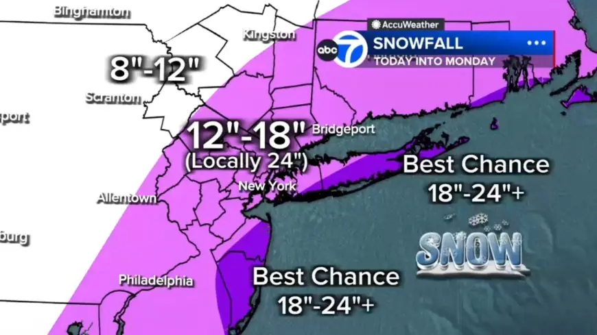
Weather threats: blizzard, wind and coastal flooding
Every county in the region is under a Blizzard Warning. Forecast totals call for 12 to 18 inches across most of the region, with localized 18 to 24 inches in a central corridor from the Jersey Shore to Long Island and the best chance for 24-plus inches on the East End of Long Island and parts of the Jersey Shore. Areas north and west such as Pike, Sullivan and Ulster counties could see up to 12 inches.
Coastal flooding is a separate hazard: winds whipping off the ocean could push water inland, producing up to 3 feet of coastal inundation around high-tide cycles tonight into Monday morning, particularly along Long Island and the Jersey Shore.
Flights and airports: more than 7, 000 disruptions
Travel disruption is already severe. The total number of disrupted flights reached more than 7, 000 as of 6 a. m. ET, with 6, 456 U. S. flights canceled and an additional 547 U. S. flights delayed through Tuesday. Jetblue, American Airlines, Delta, Southwest and United have announced they will waive change and cancellation fees ahead of the storm at many major Northeast hubs. Maintenance crews were shown clearing snow from the taxiway at LaGuardia as the storm spread across a large swath of the United States on Jan. 26, 2026, and travelers have been pictured waiting at John F. Kennedy International Airport in prior winter travel disruptions on Nov. 18, 2025.
Warnings, health risks and local impact
Blizzard warnings are in place for New York City and the New Jersey coastline, while winter storm watches and warnings are in effect for Boston, Philadelphia, Washington, D. C., and Baltimore. The National Weather Service warned gusts up to 55 mph could create whiteout conditions that will make travel treacherous and potentially life-threatening, and forecasters said the strong winds combined with heavy, wet snow will likely result in scattered to numerous power outages. Fox Weather forecasts parts of the Northeast could see snow totals of over a foot beginning Sunday, and forecasters expect the heaviest snow to begin Sunday night, with potential 18 to 24 inch totals Sunday night into Monday in New York City, Philadelphia and Boston. A Tennessee man died after suffering a heart attack while shoveling snow, underscoring the health risks of heavy snowfall.
What to expect next
This morning offered a light mix and mainly wet roads with visibility issues in spots; the afternoon will bring the transition from rain to snow for NYC and New Jersey and intensifying snowfall after lunchtime. Tonight is expected to produce the worst conditions with widespread heavy snow, 1 to 2 inch per hour snowfall rates and near-zero visibility. Heavy snow should continue through Monday morning with improving conditions by mid-morning and snow tapering the second half of the day, though winds will remain strong and travel impacted. The storm is expected to affect the region Sunday and Monday, and flight disruptions have been tallied through Tuesday.