


New York Blizzard 2026: Historic NYC Snow Forecast, NJ State of Emergency, and JFK Airport Chaos — Everything You Need to Know Right Now
A dangerous and potentially historic New York blizzard is slamming the Northeast right now. The National Weather Service has issued its first Blizzard Warning for New York City since 2017, with the snow forecast calling for up to 24 inches across the five boroughs. States of emergency are active in both New York and New Jersey. JFK Airport is in near-total shutdown. Here is everything you need to know, updated as of Sunday, February 22, 2026.
What Is a Blizzard — and Why the NWS Issued the Warning
A Blizzard Warning is issued when the National Weather Service expects sustained winds or frequent gusts of 35 mph or higher combined with falling or blowing snow that reduces visibility to one-quarter mile or less for at least three hours. This is not a standard winter storm warning — it is the most severe classification available for a snowstorm.
NYC's Blizzard Warning is the first since March 2017. It is in effect from 6:00 AM ET Sunday, February 22, through 6:00 PM ET Monday, February 23, covering all five boroughs, Long Island, and coastal Connecticut.
NYC Snow Forecast: How Much Snow Are We Getting?
While the NWS initially predicted 13 to 18 inches of snow, the latest numbers from Governor Kathy Hochul indicate New York could see closer to 18 to 24 inches. New York City is expected to get as many as 15 inches, with a slight chance of that total rising to 21 inches. Brooklyn and Queens could see 16 to 17 inches, with a possibility of reaching 24 inches in some spots. Parts of Suffolk County could see at least 18 inches, potentially climbing to 22 inches.
There is a 10% chance snowfall could exceed 20 inches. Changes in storm track could still result in more or less final accumulation totals.
| Area | Snow Forecast (NWS) | Worst-Case Scenario |
|---|---|---|
| NYC Five Boroughs | 15–18 inches | Up to 21 inches |
| Brooklyn / Queens | 16–17 inches | Up to 24 inches |
| Long Island (Suffolk) | 18+ inches | Up to 22 inches |
| New Jersey Coast | 10+ inches | Up to 24 inches |
Snow Timeline: When Will It Be Worst?
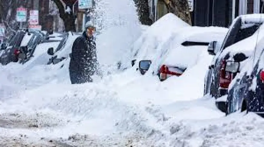
Snow began light Sunday morning with slightly above-freezing temperatures, keeping early accumulations small. The heaviest snow arrives after sunset Sunday and continues into early Monday morning before tapering. Sunday night travel is a mess — heavy snow combined with 50–55 mph wind gusts will create whiteout conditions. The Monday morning commute will be terrible, with blowing snow and reduced visibility even after accumulation slows.
Snowfall rates during peak hours are expected to reach 1 to 2 inches per hour, with potential gusts of 50 to 60 mph near the coast producing whiteout visibility and widespread power outage potential due to downed trees and lines.
NJ State of Emergency and New York Emergency Declarations
New Jersey Governor Mikie Sherrill declared a State of Emergency across all 21 counties, effective 12:00 PM ET Sunday, February 22, 2026, via Executive Order No. 14. Snow accumulations are expected to exceed 10 inches statewide, with some coastal communities bracing for as much as 24 inches.
New York Governor Kathy Hochul declared a state of emergency for more than 20 counties, including all of New York City, stating: "We received word that it's even worse than we expected, and it is a rapidly deteriorating situation. This storm is one to take seriously."
New Jersey's commercial vehicle travel restriction began at 3:00 PM ET Sunday on all major interstates — including I-76, I-78, I-80, I-195, I-280, I-287, I-295, and I-676, as well as the NJ Turnpike, Garden State Parkway, and Atlantic City Expressway.
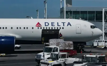
JFK Airport Cancellations: Thousands of Flights Scrapped
As of Sunday, February 22, over 2,700 flights have been canceled to, from, and within the US. JFK Airport is the hardest-hit hub with 651 cancellations. LaGuardia follows with 523 cancellations. Newark Liberty International has 376 cancellations. Airlines have canceled over 5,000 flights through Monday.
American Airlines has suspended all operations at LaGuardia, JFK, and Philadelphia beginning Sunday afternoon through Monday, with a resumption planned for Tuesday, February 24, as soon as conditions safely allow.
| Airport | Sunday Cancellations | Monday Outlook |
|---|---|---|
| JFK | 651+ flights | 70–80% of schedule |
| LaGuardia | 523+ flights | 80%+ of schedule |
| Newark (EWR) | 376+ flights | Significant disruption |
All major carriers — Delta, United, JetBlue, American, Southwest, Singapore Airlines, Emirates, Turkish Airlines, and Air Canada — are offering fee-free rebooking for Sunday and Monday departures. Check directly with your airline before heading to any airport.
What AccuWeather and The Weather Channel Are Saying
AccuWeather senior meteorologist Carl Erickson described this storm as a "major nor'easter" with "very strong winds" and "treacherous travel conditions." He added that the snow is expected to stay heavy until mid-Monday morning before tapering off by late afternoon.
Meteorologists are classifying this event as a rapidly intensifying bomb cyclone, and some forecasters are calling it a potential "top-five" historic event for the five boroughs of New York City.
What You Should Do Right Now
The National Weather Service is advising all residents in the path of the storm to stock up on three days' worth of non-perishable food, water, medications, and other essentials.
- Stay indoors Sunday night through Monday morning
- Avoid all road travel — conditions will be life-threatening overnight
- Do not go to JFK, LaGuardia, or Newark without confirming your flight is operating
- Expect power outages — charge devices now
- Check on neighbors — especially elderly residents
Conditions will begin improving Monday afternoon as the storm system pulls away to the east, with dry skies and sunshine expected Tuesday, February 24.