


Blizzard Warning: blizzard warning expanded across Tri-State as major East Coast storm approaches
A dangerous and potentially historic winter storm will slam the Tri-State area later today, bringing blizzard conditions, heavy snow, damaging winds and coastal flooding. The blizzard warning has been expanded across the region as the storm — poised to be the biggest since the January 2016 event — intensifies through the afternoon and peaks overnight.
How the storm is forming: Ohio Valley energy meets Gulf and ocean moisture
The system involves the convergence of energy from the Ohio Valley colliding with Gulf and ocean moisture, producing a storm that almost resembles a winter hurricane. That setup will allow rapid intensification through the afternoon and a peak overnight, with heavier bands developing by evening.
Blizzard Warning covers every county as visibility collapses and winds strengthen
Every county in the region is under a Blizzard Warning. Visibility is already reduced in spots, with White Plains down to 0. 2 miles, and travel is expected to grow increasingly difficult as heavier snow organizes later today. By evening the forecast calls for snowfall rates of 1 to 2 inches per hour and wind gusts of 50 to 60 mph near the coast, producing whiteout visibility and a widespread potential for power outages from downed trees and lines.
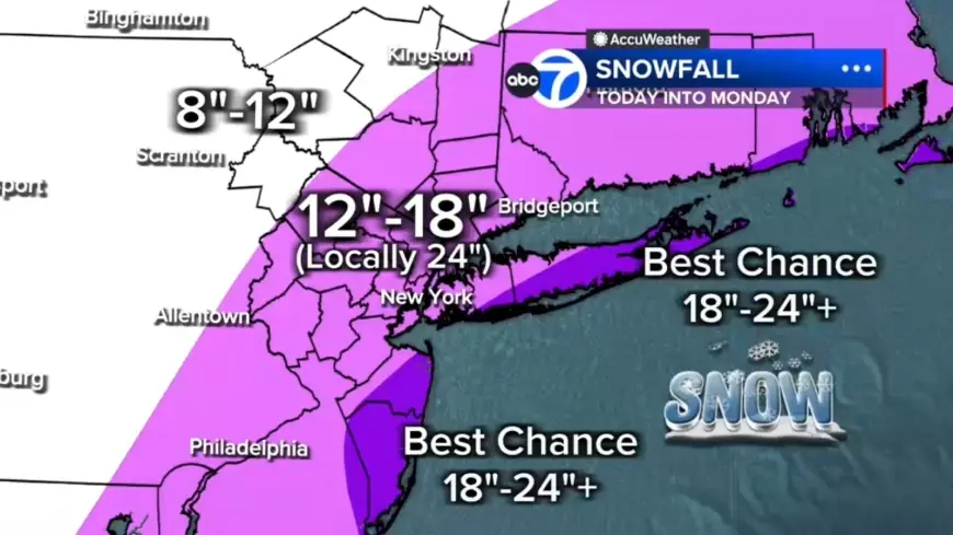
Expected snow totals: 12–18 inches across most, localized 18–24 and 24-plus pockets
With hours of heavy snow overnight, totals will pile up quickly. The bulk of the region is forecast to see 12 to 18 inches. A central corridor from the Jersey Shore to Long Island could pick up localized 18 to 24 inches, and the best chance for 24-plus inches is on the East End of Long Island and parts of the Jersey Shore. Areas north and west, including Pike, Sullivan and Ulster counties, could see up to 12 inches.
Coastal flooding and tide timing: up to 3 feet of inundation tonight into Monday morning
Winds whipping off the ocean will push water inland, creating a coastal flooding threat. Up to 3 feet of coastal inundation is possible around high-tide cycles tonight into Monday morning, especially along Long Island and the Jersey Shore. Those tide-driven surges combined with 50 to 60 mph gusts near the coast increase the risk to low-lying shorefront areas.
Local conditions and timing: wet roads, sleet in Ocean County, and a Westchester road ban
This morning began with a light mix and mainly wet roads, which may delay initial snow accumulation but should not last long. Light snow is falling across Sullivan, Ulster, Dutchess and Orange counties and parts of northwest New Jersey, while most of New Jersey is seeing rain early. Some sleet mixed in around Ocean County before transitioning to rain. The strengthening coastal storm will tap into just enough cold air to flip rain to snow across New York City and New Jersey by midday, and after lunchtime snow becomes more widespread and significantly more intense.
Tonight into Monday: worst conditions, then gradual improvement
The worst conditions are expected tonight: widespread heavy snow with 1 to 2 inches per hour rates, near-zero visibility in blizzard conditions, and a significant power outage risk. Heavy snow is forecast to continue through early Monday morning, with improving conditions by mid-morning. Snow should taper in the second half of the day Monday, but winds will remain strong and travel will continue to be impacted. Westchester County will institute a complete road ban beginning at 9 pm Sunday through 10 am Monday.
Live updates are being posted frequently as the situation unfolds; residents should prepare for rapidly deteriorating conditions and impacts to travel, power and coastal communities.