


Baltimore Weather: Nor'easter Brings Rain Then Heavy Snow Sunday into Monday
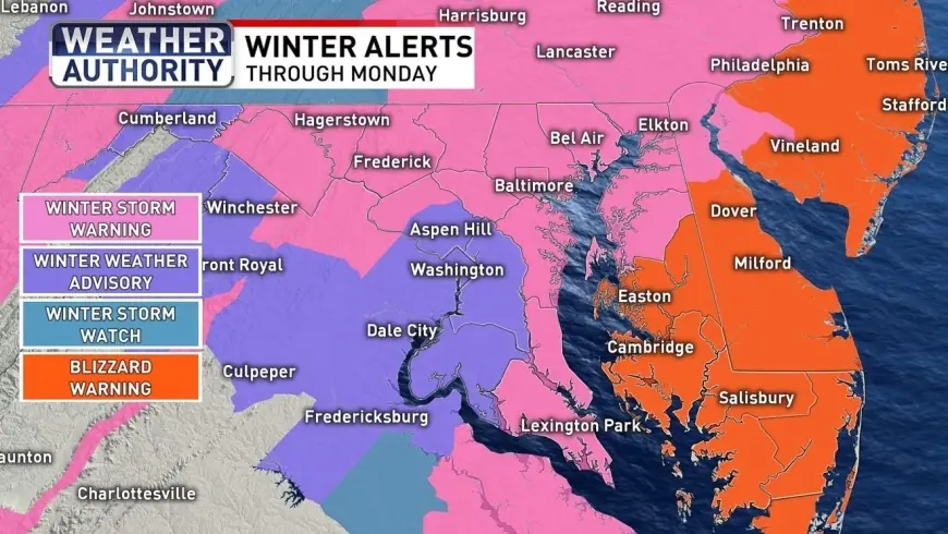
A nor'easter moving up the East Coast will bring heavy rain that transitions to accumulating snow across Maryland starting Sunday, producing winter alerts that will shape baltimore weather and travel through Monday morning. Winter Storm Warnings and other alerts are in effect for broad portions of the state as the system approaches.
Baltimore Weather: Timing and snowfall totals
The storm will arrive as a chilly rain in the Baltimore metro just before sunrise Sunday and persist through the day, with a wintry mix at times. As temperatures drop below freezing Sunday evening and overnight, precipitation will change over to snow and continue through Monday morning. This nor'easter will be the primary factor in baltimore weather impacts across the region.
Forecast guidance in recent coverage places the most likely snowfall totals along the I-95 corridor in the 3–6 inch range. Northeastern Maryland may see higher amounts, roughly 6–8 inches, while the Eastern Shore could receive 8–10 inches or more. Totals closer to the District proper are expected to be lower, nearer 2–4 inches in many locations.
Coastal impacts and strong winds
Blizzard-level conditions are possible along parts of the Eastern Shore and adjacent beaches, where higher snowfall and strong northerly winds will create blowing snow and poor visibility. Wind gusts along the coast could reach the neighborhood of 40 mph, and maritime watches point to northerly winds increasing substantially overnight with gale-force gusts over the bay and nearshore waters. Minor tidal flooding, including up to about one foot of inundation in vulnerable spots, is possible late Sunday night into early Monday on some beaches.
Local preparations and travel guidance
State and local officials have declared readiness measures ahead of the storm. A State of Preparedness has been issued for Maryland, with authorities urging residents to avoid unnecessary travel and to prepare for potential power outages. Municipal crews plan to begin salt pretreatment of major roadways around midday Sunday where conditions permit, and transportation departments will mobilize plows and response teams as the precipitation changes to snow.
Communities are taking steps to support those in need: cold-weather alerts and openings of hypothermia shelters have been announced where applicable. Some county-level advisories call for parking in driveways or on specified sides of streets to facilitate clearing operations, and officials have noted that certain bus services will not operate on Sunday. Motorists should expect slick roads and reduced visibility once snow begins to fall in earnest Sunday night.
Short-term outlook and what comes next
Conditions should begin to improve Monday as the storm pulls away around daybreak, though it will remain breezy with highs in the upper 30s. Tuesday is forecast to stay chilly, with highs in the mid-30s, before a return to milder conditions later in the week: upper-40s to low-50s by midweek, which will accelerate snowmelt where accumulation occurs. The next chance for rain is in the forecast later in the week on Thursday.
Key takeaways:
- Expect a rain-to-snow transition Sunday into Monday with most I-95 corridor totals near 3–6 inches.
- Higher totals—6–10 inches or more—are possible in northeastern and coastal sections of Maryland.