


Blizzard Warning Expanded as Gov. Sherrill Declares State of Emergency — NYC Area Likely to See 12–18 Inches, Coastal Flooding Threat
Blizzard warnings have been expanded across the Tri-State region and Philadelphia as Gov. Sherrill declares a state of emergency for New Jersey ahead of a dangerous, potentially historic winter storm that could bring heavy snow, damaging winds, and coastal flooding. This development matters because the storm is expected to produce rapidly intensifying snowfall and powerful coastal impacts that threaten travel, infrastructure and public safety across a wide area.
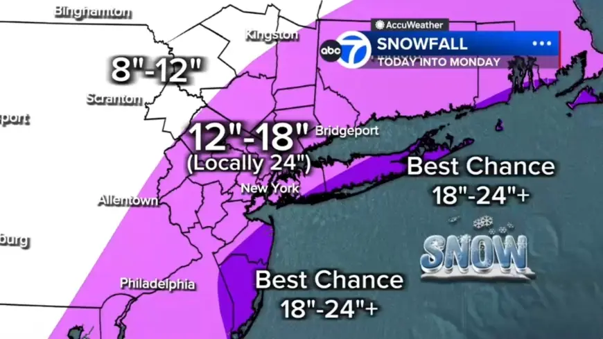
Blizzard warnings and the area under threat
Every county in the region is under a Blizzard Warning. The warning area specifically includes Philadelphia, several suburban Pennsylvania counties, the entirety of New Jersey and Delaware. The last time the region faced a blizzard warning was March 2017, making this a relatively rare event. Officials have moved to emergency posture in New Jersey with a state of emergency declared by Gov. Sherrill.
Storm origins and why this may be historic
Forecasters describe the storm as the result of energy from the Ohio Valley colliding with Gulf and ocean moisture, creating a strengthening coastal system that almost resembles a winter hurricane. The storm is poised to be the biggest snow-maker to slam the Tri-State area since the storm of January 2016, which was the largest on record for New York City.
Snowfall totals, rates and local differences
Snow will pile up quickly once the changeover occurs. Expected totals and hotspots include:
- 12 to 18 inches across most of the region
- Localized 18 to 24 inches in a central corridor from the Jersey Shore to Long Island
- Best chance for 24-plus inches: East End of Long Island and parts of the Jersey Shore
- Up to 12 inches north and west in counties such as Pike, Sullivan and Ulster
Snowfall rates during the worst of the storm are forecast at 1 to 2 inches per hour, which can dramatically increase accumulation in a short period.
Timing, visibility and immediate conditions
The morning begins with scattered light snow and rain, with light snow already falling across Sullivan, Ulster, Dutchess, Orange and parts of northwest New Jersey. Most of New Jersey is seeing rain early; some sleet mixed in around Ocean County before transitioning to rain. Roads are mainly wet to start, which may delay initial accumulation but will not prevent the rapid intensification expected later in the day.
Visibility is already reduced in spots, with White Plains down to 0. 2 miles. After midday the strengthening coastal storm will tap into enough cold air to flip rain to snow across New York City and New Jersey by midday, with snow becoming more widespread and intense after lunchtime. By evening, heavier bands will develop and conditions will deteriorate rapidly.
Wind, coastal flooding and power outage risk
Winds will be a major hazard. Near the coast, gusts of 50 to 60 mph are expected. The combination of strong onshore winds and rising seas creates a coastal flooding threat: up to 3 feet of coastal inundation is possible around high-tide cycles tonight into Monday morning, especially along Long Island and the Jersey Shore. Gusty winds could bring down tree branches and result in isolated power outages, and widespread outages are possible where heavy, wet snow and strong gusts combine to down lines and topple trees.
Public safety measures, travel restrictions and what residents should do
New Jersey has issued a commercial vehicle travel restriction on multiple Interstate highways starting at 3 p. m. Sunday. Drivers are urged to use caution and consider staying off the roads from Sunday evening through Monday morning as snowfall rates pick up and blizzard conditions develop. When blizzard conditions are met, they consist of three or more hours of winds gusting to 35 miles per hour or greater, falling or blowing snow, and visibility less than a quarter of a mile; there is no minimum amount of snow required to meet the blizzard criteria.
Light precipitation is expected to begin Sunday morning. In and around Philadelphia, areas northwest of the city will likely begin with light snow showers while ground temperatures above freezing and air temperatures in the mid 30s mean early snow may initially melt on contact. A mix of rain and snow is expected around Philadelphia initially, with rain showers for areas south and east. The high temperature on Sunday is forecast to reach about 39 degrees, with temperatures falling later in the day; as temperatures drop later in the evening, rain or mixed precipitation will change to snow for all areas, setting up overnight accumulation.
When the worst will ease and remaining uncertainties
Tonight is expected to bring the worst conditions with widespread heavy snow, intense snowfall rates, near-zero visibility and ongoing power outage risk. Heavy snow will continue through early Monday morning, with improvement by mid-morning and snow tapering during the second half of the day as the coastal storm continues to strengthen and move away from the coast. Details may evolve as the system progresses; recent updates indicate timing and exact totals could change.
Readers should follow local advisories and heed travel restrictions and emergency declarations as the storm unfolds.