


Blizzard Warning: Major East Coast Storm Expected Sunday Night into Monday
A blizzard warning is in effect for New York City and large portions of the Tri-State area as a powerful winter storm moves in Sunday night into Monday. The warning matters because the system is forecast to produce heavy, banded snow, high winds and potential widespread outages that will disrupt travel and infrastructure across the region.
Blizzard Warning covers Long Island, all five boroughs, Westchester and Rockland counties
Official blizzard warnings have been posted for Long Island, all five boroughs of New York City, Westchester and Rockland counties, coastal Connecticut and much of New Jersey. Eyewitness News will carry live updates and readers are urged to check back frequently for developments.
Jeff Smith: Storm could rival January 2016 event
Eyewitness News Meteorologist Jeff Smith says this could be one of the most significant snowstorms the region has seen in years. The storm is poised to be the biggest snow-maker to slam the Tri-State area since the January 2016 event, which remains the largest snowstorm on record for New York City. The last time the area faced a blizzard warning was March 2017, underscoring the rarity of this setup.
The system is being driven by a convergence of energy from the Ohio Valley colliding with Gulf and ocean moisture, a combination that Smith says will produce a storm that almost resembles a winter hurricane. That collision of atmospheric energy and abundant moisture is the underlying cause of the expected rapid coastal intensification and heavy snow bands.
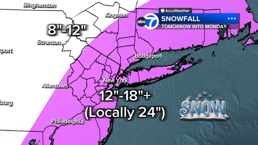
Snow rates and totals threaten Long Island and the Jersey Shore
Snow rates are forecast to be intense, with bands capable of dropping 2 to 3 inches per hour and, in some areas, remaining overhead for hours. Most of the region is projected to see 12 to 18 inches of snow, with localized totals up to 24 inches or more where the heaviest bands stall. Long Island and parts of the Jersey Shore currently have the highest likelihood of hitting those extreme amounts.
Farther north and west, including the Poconos and Catskills, totals should be lower — roughly 8 to 12 inches — reflecting less access to the storm’s core moisture.
Winds, visibility and the risk of downed trees and outages
The storm meets the criteria for a full-blown blizzard: winds gusting 35 mph or higher, heavy snow, and visibility under a quarter mile for at least three consecutive hours. The region may see 10 to 12 hours of true blizzard conditions Sunday night into Monday. Winds will increase throughout Sunday and peak overnight, with gusts over 40 mph across the region and potentially up to 60 mph on Long Island.
Those high winds combined with wet, heavy snow raise a significant risk for downed trees and widespread power outages. Road conditions are expected to deteriorate rapidly Sunday evening, and the Monday morning commute may be impossible in some areas. Snow will gradually taper Monday afternoon, though gusty winds and scattered blowing snow are likely to continue.
American Airlines suspends operations at LaGuardia, JFK and Philadelphia
American Airlines will suspend operations at LaGuardia, JFK and Philadelphia beginning Sunday afternoon through the day Monday because of the blizzard. The airline said teams are working around the clock and will be ready to resume operations at the affected airports on Tuesday, Feb. 24 as soon as conditions allow airlines to safely do so.
Timing and short-term outlook to midweek
Conditions are expected to remain quiet Saturday evening while clouds thicken overnight; a few rain or snow showers may pop up early Sunday, with temperatures remaining above freezing to start the day. By midday Sunday visibility will begin dropping as steadier snow develops, especially from New York City south and west. After sunset, temperatures will fall and the storm will rapidly intensify offshore, pulling heavy snow bands directly into the region.
Tuesday will turn colder and breezy as cleanup continues. Another system is possible Wednesday, but early indications suggest it will be significantly weaker.
What makes this notable is the combination of abundant coastal moisture and strong inland energy, which can concentrate persistent heavy bands over the same locations and drive the localized 24-inch totals that forecasters are highlighting.
Readers should treat travel plans with caution, prepare for potential power outages, and monitor official updates as the storm approaches.