


Blizzard Warning Issued as Powerful Storm Poised to Slam Tri-State Sunday Night into Monday
A blizzard warning is now in effect for large portions of the Tri-State area as a powerful winter storm moves in Sunday night into Monday, threatening heavy snow, damaging winds and the potential for widespread power outages. The timing matters because rapid offshore intensification after sunset is expected to pull heavy snow bands directly into population centers during the overnight period.
Blizzard Warning zones: Long Island, all five boroughs and neighboring counties
Blizzard Warnings cover Long Island, all five boroughs of New York City, Westchester and Rockland counties, coastal Connecticut and much of New Jersey. The storm meets full blizzard criteria: winds gusting 35 mph or higher, heavy snow and visibility under a quarter mile for at least three consecutive hours. Forecasters project 10 to 12 hours of true blizzard conditions Sunday night into Monday in the warned areas.
Storm mechanics: Ohio Valley energy colliding with Gulf and ocean moisture
The storm’s strength stems from the convergence of energy from the Ohio Valley with moisture from the Gulf and the ocean, a setup that forecasters say almost resembles a winter hurricane. That collision will allow the system to rapidly intensify offshore after sunset, pulling persistent heavy snow bands into the region and producing the potential for prolonged intense snowfall.
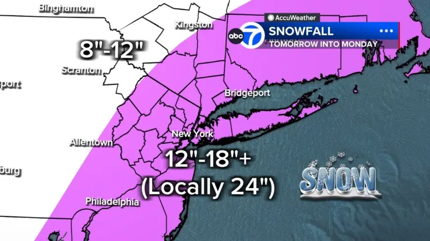
Snow totals and rates: 2–3 inches per hour, 12–18 inches typical, up to 24+ locally
Forecasters are warning of snow bands capable of dropping 2 to 3 inches per hour, and in some places those bands could sit overhead for hours. Most of the Tri-State region is projected to see 12 to 18 inches of snow, with localized totals up to 24 inches or more where the heaviest bands stall. Long Island and parts of the Jersey Shore currently have the highest likelihood of hitting those extreme amounts. Farther north and west—specifically the Poconos and the Catskills—are expected to receive lower totals, roughly 8 to 12 inches, because those areas will have less access to the storm’s core moisture.
Winds, outages and travel: gusts over 40 mph regionwide, up to 60 mph on Long Island
Winds will increase throughout Sunday, peaking overnight with gusts over 40 mph across the region and potentially up to 60 mph on Long Island. Combined with wet, heavy snow, those gusts create a significant risk for downed trees and power outages. Road conditions will deteriorate rapidly Sunday evening, and the Monday morning commute may be impossible in some areas. Snow is expected to gradually taper Monday afternoon, but gusty winds and scattered blowing snow will persist.
American Airlines suspends operations at LaGuardia, JFK and Philadelphia
American Airlines will suspend operations at LaGuardia, JFK and Philadelphia beginning Sunday afternoon through the day Monday due to the blizzard. The airline said teams are working around the clock and will be ready to resume operations at the affected airports Tuesday, Feb. 24 as soon as conditions allow airlines to safely do so.
Timing and short-term outlook: quiet Saturday, deterioration Sunday into cleanup on Tuesday
Conditions remain quiet Saturday evening with clouds thickening overnight. A few rain or snow showers may occur early Sunday while temperatures stay above freezing to start the day. By midday Sunday, visibility will begin dropping as steadier snow develops, especially from New York City south and west. After sunset, the storm rapidly intensifies offshore. Snow will taper Monday afternoon with cleanup continuing; Tuesday is expected to be colder and breezy as crews work to clear streets and restore service. Another system is possible Wednesday, but early indications suggest it will be significantly weaker.
Eyewitness News Meteorologist Jeff Smith emphasized the historic potential of the event, noting this storm is poised to be the biggest snow-maker to slam the Tri-State area since the January 2016 storm, which remains the largest on record for New York City. The last time the region faced a blizzard warning was March 2017, underscoring the rarity of the current threat. What makes this notable is the combination of rapid intensification offshore and high moisture availability, which together drive the risk of prolonged heavy bands, extreme totals in localized corridors and widespread impacts on travel and power.
Stay with Eyewitness News and First Alert Weather for live updates as the situation evolves.