


Fire Weather Watch and Red Flag Warning Raise Fire Risk Across Central West Florida
A red flag warning for Sunday and a fire weather watch for Monday put parts of Central West Florida on alert as dry ground, gusty winds and low humidity combine to increase the chance that any flame could spread quickly. The National Weather Service issued the red flag warning at 12: 23 p. m. on Saturday, and officials urged residents to exercise extreme caution outdoors.
Red flag warning details and affected counties
The red flag warning is valid Sunday between 1 p. m. and 7 p. m. and covers Coastal Levy, Inland Levy, Citrus, Hernando and Sumter counties. Residents there can expect northwest winds of 10 to 15 mph with gusts up to 25 mph and relative humidity falling as low as 28 percent.
Fire Weather Watch in effect Monday
A Fire Weather Watch is in effect on Monday. The watch means the fire weather threat is elevated because of dry ground and gusty winds; officials advised exercising extreme caution if outdoors and to heed any burn ban in place.
Local forecast: a front, cooler conditions and a likely freeze
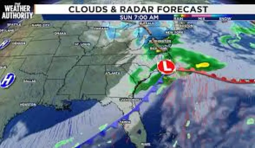
Cloud cover will increase tonight and conditions will be mild for this time of year, with low temperatures in the 50s and 60s. A front will bring a few showers overnight through Sunday morning; activity will not be widespread and rainfall is expected to be generally under a tenth of an inch. Behind the front, highs on Sunday will be in the 60s with mostly cloudy skies and breezy conditions going into early next week. Lows Sunday night will fall into the 30s and 40s.
Monday is forecast to be the coolest day of the week, with morning temperatures near 40 degrees and afternoon highs only in the low to mid 50s as a northerly flow pushes cooler air into the area. Another big story is a widespread frost/freeze likely Tuesday morning, with lows in the 20s and 30s and wind making it feel like the 20s for most of the area.
Guidance to reduce fire risk
The National Weather Service outlined steps residents can take to lower the risk of fires igniting and spreading during the red flag period:
- If burning is authorized in your vicinity, ensure burn barrels have a weighted metal cover with holes no larger than 3/4 of an inch.
- Dispose of smoking materials responsibly: do not haphazardly discard lit cigarette butts or fling cigarettes or matches from moving vehicles.
- Extinguish outdoor fires thoroughly: drown them with ample water, stir to confirm everything is cold to the touch, and submerge charcoal in water until it is completely cooled. Never dispose of live charcoal on the ground and do not abandon a fire unattended.
Drought, weekly outlook and quick forecast numbers
The latest drought monitor shows the area of “extreme” drought continues to expand in coverage and now covers most of the area. High pressure is expected to keep the rest of the upcoming week fairly dry; another front could approach later in the week, but forecast rainfall accumulation looks minimal and not enough to end the drought.
Forecast snapshots provided for the area include Sunday: a few morning showers then afternoon sun, high 68, low 34; Wednesday: mostly sunny, high 70, low 45.
Page notes and unrelated automated items
An automated note on one weather page stated that the article was produced using artificial intelligence and publicly available data. The same page included unrelated automated headlines mentioning Moore, Jevon Carter, Jalen Green, Inter Miami and Jacob Bridgeman.
Chris Holtzman joined the station in October 2025. He is a member of the American Meteorological Society and is a Certified Broadcast Meteorologist designated by the American Meteorological Society.
Watch for the red flag warning window Sunday from 1 p. m. to 7 p. m. in the listed counties and the Fire Weather Watch on Monday; officials stressed that taking precautions now can reduce the chance that a small fire becomes a major incident.