


Coastal Flood Warning Along the Northeast Coast: High Tide Surge Threat Grows as Powerful Winter Storm Nears
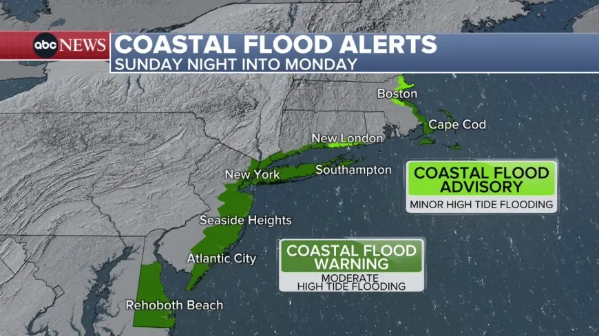
A coastal flood warning is in effect for parts of the U.S. Northeast as a powerful late-winter storm pushes water toward shorelines and vulnerable bays, raising the risk of inundation during peak high tide windows. The biggest concern is not just water on roads, but rapid saltwater intrusion into low-lying neighborhoods, parking lots, marinas, and waterfront business districts at the same time snow and wind reduce visibility and slow emergency response.
In Eastern Time, the highest-risk period is expected from Sunday afternoon through the overnight hours into early Monday, when storm surge and wave run-up can stack on top of already elevated tides.
What a Coastal Flood Warning Means and Why It’s Different From an Advisory
A coastal flood warning signals that moderate to potentially major coastal flooding is occurring, is imminent, or is expected soon. In plain terms: seawater is expected to spill into places that normally stay dry during ordinary high tides. That can mean water crossing bulkheads, overtopping seawalls, pushing through storm drains, and spreading inland across the flattest terrain.
An advisory is typically used for minor, nuisance flooding, the kind that causes a few impassable spots but limited structural impacts. A warning is a higher bar: it assumes a serious risk to property and, in some locations, a real threat to life if people drive into floodwater or get stranded.
What Happened: Storm Track and Wind Setup Are Piling Water Toward the Shore
The storm approaching the Northeast has the classic ingredients for coastal flooding:
-
Strong, sustained onshore wind that pushes water into bays and tidal rivers
-
Low pressure that allows sea level to rise temporarily
-
Large surf that can throw water beyond normal tide lines
-
Limited drainage capacity when storm drains are blocked by snow, ice, or debris
The result is “water plus timing.” Even a modest surge can become damaging if it peaks near the highest tide cycle, and the impacts often spread well beyond the beach itself into back bays, canals, and harbor neighborhoods.
Behind the Headline: Why This Warning Is Especially Disruptive
Context
Coastal flood warnings in winter are uniquely challenging because hazards compound. Flooding can occur while temperatures are low, visibility is poor, and roads are already compromised by snow or ice. That makes detours harder, towing riskier, and recovery slower.
Incentives and constraints
-
Local officials want residents to stay off the roads, but many waterfront areas rely on limited access routes that flood early and trap late.
-
Businesses near the water face a tough call: close early and lose revenue, or stay open and risk damage to equipment, inventory, and electrical systems.
-
Emergency services must balance calls for stranded vehicles with the danger of sending crews into deepening water and worsening winds.
Stakeholders
-
Waterfront residents in ground-floor units, basement apartments, and homes with crawl spaces
-
Small businesses along boardwalks, marinas, and harborfront strips
-
Commuters using low-lying causeways and shoreline parkways
-
Utilities and public works teams that manage storm drains, pumps, and downed lines
Second-order effects
Even if water recedes quickly, saltwater can corrode vehicles, damage electrical panels, contaminate basements, and weaken roadbeds. If flooding overlaps with heavy snow, plows may be unable to clear key routes, and recovery can stretch from hours into days.
What We Still Don’t Know: The Missing Pieces That Decide Severity
Several factors can still shift impacts up or down:
-
Exact timing of peak surge versus the highest tide cycle in each community
-
How long strong onshore winds persist after the first surge peak
-
Whether wave action causes overtopping that adds damage beyond still-water flooding
-
How much snow and ice blocks drainage, turning short-lived flooding into longer ponding
-
The localized “funnel” effect in certain bays and tidal rivers that can amplify water levels
What Happens Next: Scenarios to Watch and Their Triggers
-
Brief but widespread roadway flooding
Trigger: surge peaks close to a high tide cycle, water clears within a few hours, but multiple low points become impassable. -
Moderate flooding with property impacts near the waterfront
Trigger: onshore winds persist through multiple tide cycles, pushing water into garages, basements, and ground floors. -
Overtopping and erosion along exposed shorelines
Trigger: large surf aligns with peak tide, sending waves over protective dunes or seawalls and cutting off access roads. -
Extended disruptions into Monday
Trigger: floodwater recedes but heavy snow and wind delay cleanup, leaving closures, disabled vehicles, and power issues. -
Patchwork impacts that surprise drivers
Trigger: flooding is highly neighborhood-specific, with dry streets one block inland and deep water at the next intersection.
What To Do During a Coastal Flood Warning
-
Do not drive through saltwater flooding, even if it looks shallow
-
Move vehicles to higher ground before peak tide if you live near the water
-
Keep away from jetties, seawalls, and piers where waves can sweep people off
-
If you are in a flood-prone ground-floor space, elevate valuables and unplug low outlets
-
Charge devices and prepare for localized power interruptions
-
If local officials close roads, treat closures as firm, not advisory
Coastal flood warnings are short-fuse events with outsized consequences, especially when paired with a major winter storm. The practical goal is simple: stay out of floodwater, avoid last-minute travel near the shoreline, and make protective moves before the tide window hits.