


Fire Weather Watch and Red Flag Warning Raise Risks as Drought Expands Across the Region
A fire weather watch is in effect Monday as officials warn of elevated wildfire risk driven by dry ground and gusty winds, with a red flag warning also slated for Sunday in parts of the region. These alerts come amid an expanding area of extreme drought and a forecast that shifts from mild, breezy conditions to much cooler temperatures and a strong freeze threat.
Fire Weather Watch
The fire weather watch is in effect on Monday, reflecting a heightened fire weather threat tied to dry ground and gusty winds. Residents are advised to exercise extreme caution if they will be outdoors and to take note of any burn ban in place.
Red Flag Warning Details and Local Impacts
A red flag warning is in effect on Sunday. A separate advisory was issued at 12: 23 p. m. on Saturday establishing a red flag warning valid Sunday between 1 p. m. and 7 p. m. that covers Coastal Levy, Inland Levy, Citrus, Hernando and Sumter counties. Expected winds are northwest 10 to 15 mph with gusts up to 25 mph and relative humidity may fall as low as 28 percent. A red flag warning signals that warm temperatures, very low humidities and stronger winds are expected to combine to increase the risk that fires will spread rapidly.
Forecast Timeline and Temperatures
- Rest of the day: partly to mostly cloudy and breezy with temperatures in the low to mid 80s; tonight will see increasing cloud cover and mild conditions for the time of year with lows in the 50s and 60s.
- Overnight into Sunday morning: a front will bring a few showers; activity is not expected to be widespread and rainfall should generally be under a tenth of an inch.
- Sunday and early next week: behind the front, much cooler and breezy conditions are expected. Highs Sunday will be in the 60s with a mostly cloudy sky; lows Sunday night will be in the 30s and 40s.
- Monday: the coolest day of the week with morning temperatures near 40 degrees and highs only in the low to mid 50s, driven by a northerly flow bringing cooler air into the area.
- Tuesday morning: a widespread frost/freeze is likely with lows in the 20s and 30s; factoring in wind, conditions will feel like the 20s for most of the area.
- Rest of the week: generally fairly dry as an area of high pressure remains overhead; another front could approach later, but rainfall accumulation looks minimal and not enough to end the drought.
Short forecast highlights listed in local briefings include: Today — Partly to Mostly Cloudy & Breezy. High 86, Low 61. Sunday — A Few AM Showers, PM Sun. High 68, Low 34. Wednesday — Mostly Sunny. High 70, Low 45.
Drought, Frost Risk and What Residents Should Know
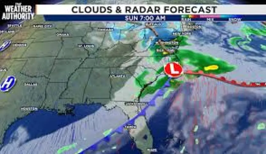
The latest drought monitor reflects the recent multi-month pattern: the area of "extreme" drought continues to expand in coverage each week and now covers most of the area. Limited rainfall ahead means drought conditions are unlikely to improve soon. With cold overnight lows and an elevated frost/freeze risk Tuesday morning, vulnerable vegetation and outdoor water-sensitive activities may be affected.
Public Guidance, Safety Steps and Community Notes
Officials emphasize extreme caution during both the red flag warning window and the fire weather watch. Practical steps to reduce ignition risk include:
- If burning is authorized, ensure burn barrels have a weighted metal cover with holes no larger than 3/4 of an inch.
- Dispose of smoking materials responsibly: avoid haphazardly discarding lit cigarette butts and do not fling cigarettes or matches from moving vehicles.
- Extinguish outdoor fires thoroughly: drown with ample water and stir to confirm everything is cold to the touch. Submerge charcoal in water until it is thoroughly cooled and never dispose of live charcoal on the ground. Do not abandon any fire without supervision.
Community information notes: anyone can view a sampling of recent comments on a regional news site, but you must be a subscriber to contribute. Conversations are opinions of readers and are subject to Community Guidelines. The paper's e-Newspaper is a digital replica of the printed paper seven days a week, available to read on desktop, mobile and in an app for subscribers only; to enjoy it every day, subscribe.
Additional local staffing and contact notes included in briefings: a local meteorologist named Chris Holtzman joined the station in October 2025 and is a member of the American Meteorological Society with certification as a Broadcast Meteorologist. For public file assistance, call 393-9801. An automated article template noted use of artificial intelligence and publicly available data; a feedback contact was provided but is unclear in the provided context.
Unrelated local notes present in the available coverage mention that certain college basketball matchups could influence NCAA tournament seedings, that a figure skating Olympic Gala took place in Milan, and that observations about individual player performance were made; these items were included alongside the weather coverage in the provided context.