Winter Storm Watch: Another Storm Could Bring 6–12 Inches to New York City and More Along the Northeast Coast
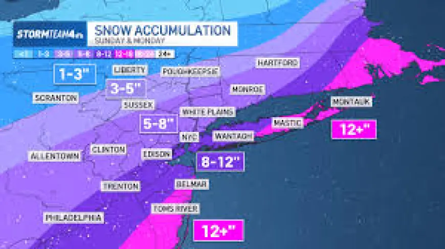
A fresh winter storm watch has taken shape as forecasts on Friday moved toward a far snowier outcome for the Mid-Atlantic and Northeast. Forecasters say snow is likely to begin Sunday, with impacts that could include heavy, wet snowfall, strong winds and coastal flooding.
What happened and what’s new
Forecast guidance shifted Friday afternoon, with models showing a much stronger snowfall signal for the region. Forecasters said the system is expected to take shape overnight Saturday and to pick up through Sunday, continuing into Monday. Meteorologists described the event as a longer-duration storm with potentially 18 to 24 hours of snowfall where the heaviest bands set up.
Between Boston and Philadelphia, there is now a greater than 50 percent probability of at least six inches of snow. In and around New York City, forecasts from the local weather office call for six to 12 inches, a range could be conservative and may increase as the forecast firmed on Saturday.
Emergency officials from Washington, D. C., to Boston have been preparing for another storm that could produce more than a foot of snow in the worst-affected spots, along with strong winds and potential coastal flooding. Forecasters warned that the system could produce blizzard conditions where heavy snow coincides with the strongest winds.
Winter Storm Watch: Behind the headline
The recent forecast shift reflects changing model guidance late Friday that amplified the snow potential. Meteorologists are tracking the interaction of two separate energy systems higher in the atmosphere; if those features align close to the coast, the storm is likely to strengthen rapidly. That alignment is a key strengthening factor cited by forecasters.
Another important constraint is the storm’s precise track. the path could still shift, and that a firm understanding of where the heaviest snow will fall may not be possible until the system organizes off the coast late Saturday or even early Sunday. The timing and amount of warm air drawn into the system also matter: in some locations, including Washington, D. C., a period of wintry mix or freezing rain before the changeover to snow could reduce final snowfall totals and create slippery conditions.
What we still don’t know
- Exact storm track and precise areas that will receive the highest snow totals.
- Whether the two upper-level energy systems will align close enough to the coast to trigger rapid strengthening.
- How much warm air will be entrained into the system and which locales, if any, will see freezing rain or a wintry mix before snow.
- The final snowfall totals for specific cities and suburbs, and whether some places will see totals above the current six to 12 inch guidance.
- The extent and timing of damaging winds and coastal flooding, including whether blizzard conditions will be widespread.
What happens next
- Rapid-strengthening scenario: If the two energy systems align near the coast when the storm organizes off the coast late Saturday, the system could intensify quickly, producing the highest snow totals, strong winds and possible blizzard conditions. Trigger: clear model agreement on coastal intensification late Saturday.
- Offshore-track scenario: If the storm organizes farther offshore, coastal and urban totals would be lower, with heavier snowfall pushed eastward. Trigger: model guidance holding a more seaward track through late Saturday and early Sunday.
- Warm-air intrusion scenario: If warm air moves in ahead of the main surge, some Mid-Atlantic locations could see freezing rain or a wintry mix that reduces snow accretion and increases slick surfaces. Trigger: observed temperature profiles showing a warm layer at low levels before the snow onset.
- Prolonged low-impact scenario: If the system does not intensify or align as currently suggested, snowfall may be lighter and shorter in duration than anticipated. Trigger: lack of model consensus on strengthening and shorter duration in subsequent forecasts.
- Compounding impacts scenario: Heavy, wet snow combined with strong winds could weigh down trees and power lines, increasing the risk of outages and complicating response efforts. Trigger: accumulation of wet snow coinciding with gusty conditions during peak snowfall.
Why it matters
The practical implications are immediate for residents, municipal services and emergency planners across the Mid-Atlantic and Northeast. Heavy, wet snow increases the risk of downed trees and power outages and is more difficult to clear, while freezing rain and wintry mix can create hazardous travel before the main snowfall arrives. Coastal communities face the additional threat of high winds and flooding, and a rapidly intensifying coastal storm could produce blizzard conditions that hamper response and recovery.
In the near term, the forecast hinge points to watch are the storm’s organization off the coast late Saturday, the alignment of upper-level energy systems, and the extent of warm-air intrusion ahead of the front. Forecasters emphasized that totals could change as the system evolves, and that preparations should account for a range of outcomes under the current winter storm watch.


