


Winter Storm Watch: NYC Faces Nor'easter Threat With Heavy Snow Overnight Sunday Into Monday
A winter storm watch is in effect for New York City as forecasters flag a possible East Coast storm and nor'easter expected to bring heavy snow overnight Sunday into Monday. The watch covers all five boroughs and outlines a concentrated window for the heaviest snowfall and other hazards.
Winter Storm Watch: Timing, Accumulation and Heaviest Band
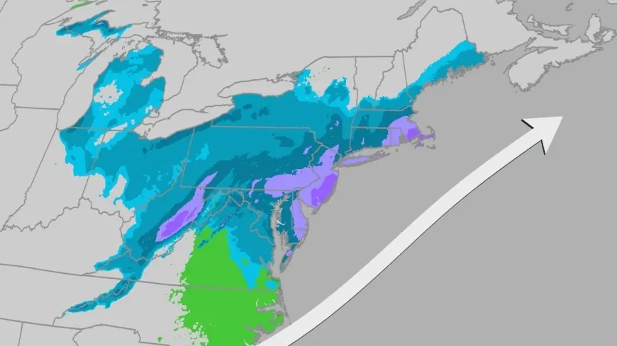
The National Weather Service has issued the Winter Storm Watch for the five boroughs, set to go into effect on Sunday at 6 a. m. and last through 6 p. m. on Monday. Forecast details in the watch highlight a multi-stage event for the city:
- Snow is likely to begin during the daylight hours on Sunday, producing wet, slushy conditions initially.
- Only about 2 inches of accumulation are expected before 8 p. m. on Sunday.
- The heaviest snow is expected between 11 p. m. on Sunday and noon on Monday, with total overnight amounts estimated at 6 to 10 inches across New York City.
These timing details create a focused period during which travel and outdoor activity could become hazardous as snowfall rates increase.
Nor'easter Risk and Related Hazards
The broader forecast flags a possible East Coast storm and nor'easter for Sunday and Monday, which brings secondary hazards beyond snow accumulation. The watch notes the potential for moderate coastal flooding and wind gusts up to 40 mph. Combined with heavy snowfall, these elements are likely to make roadways slippery and could complicate operations at area airports.
- Moderate coastal flooding is possible along exposed shorelines.
- Wind gusts could reach as high as 40 mph, increasing blowing and drifting of snow.
- Snow is expected to make roadways slippery, and the storm could affect flights at New York City airports.
Context and What This Means for the Region
The watch follows a pattern of impactful winter events in the region; a late January storm earlier this season dumped approximately a foot of snow across New York City, the heaviest snowfall the city had seen in nearly five years. This recent history underscores how quickly surface conditions can deteriorate once heavier bands arrive.
Residents and travelers in the watch area should be aware that the strongest impacts are concentrated overnight into Monday. The winter storm watch language signals a need to monitor the situation closely, as the forecasted heavy snow, gusty winds and potential coastal flooding could combine to produce significant travel disruptions.
Timing Summary (Key Windows)
- Watch period: Sunday at 6 a. m. through Monday at 6 p. m.
- Initial snow: during daylight hours Sunday; around 2 inches expected before 8 p. m.
- Heaviest snow: between 11 p. m. Sunday and noon Monday.
With a winter storm watch in place and a possible nor'easter on the horizon for Sunday and Monday, timeline clarity is critical for planning. Details may evolve as the event approaches; updates will refine timing, track and local impacts.