


Hawaii Prepares for Intensifying Heavy Rainfall
Forecasts show another round of heavy rain heading to the Hawaiian Islands. Recovery from back-to-back Kona-low storms in March remains underway.
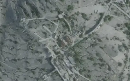
Hawaii Prepares for Intensifying Heavy Rainfall as city crews clear storm drains and rivers across Oahu. Workers manually lowered a sand plug at the Ewa drainage channel to improve flow.
Forecast and watches
The National Weather Service issued a flood watch Monday afternoon. The watch runs from Wednesday morning through Friday afternoon.
Forecasters say a deep-layered trough west of the islands will draw deep tropical moisture northward. Heavy rain and flash flooding are possible from Niihau and Kauai through Hawaii island.
Widespread rain is expected beginning Tuesday night on Kauai and continuing into the weekend. Strong southerly winds and possible thunderstorms may affect interior areas Tuesday.
A winter storm watch covers Big Isle summits above 12,500 feet. Freezing rain, ice, and up to three inches of snow are possible, with gusts near 55 mph.
Recent storm impacts and statistics
Researchers at the University of Hawaii at Manoa estimated more than two trillion gallons of water fell in March. That volume equals roughly three million Olympic-sized swimming pools.
During the 14-day Kona-low sequence, rainfall totals reached as high as 3,000 percent of normal. The first storm, March 10–16, produced up to 62 inches on Maui.
The second event, March 19–23, brought localized totals up to 61 inches. On Oahu, the Kaala station recorded about 22 inches over two days.
On March 23, intense rates of two to four inches per hour struck Manoa and Palolo valleys. Those bursts turned streams into raging torrents and triggered flash floods.
Local response and operations
The City and County of Honolulu dispatched crews across Oahu to clear waterways. Officials also emphasized monitoring dams, streams, and reservoirs with state and federal partners.
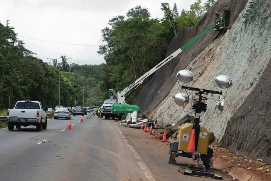
Mayor Rick Blangiardi urged residents to prepare now and announced activation of the Honolulu Emergency Operations Center on Wednesday. Crews continue debris removal, pothole repairs, and slope stabilization along key highways.
The Hawaii National Guard supports cleanup on Oahu’s North Shore. Maj. Gen. Stephen Logan said guardsmen can quickly shift to response operations if needed.
The state Department of Transportation cleared Waikane and Waiahole roadways Monday. DOT warned motorists to expect rock and tree debris from saturated slopes.
Closures and community impacts
City officials postponed scheduled town halls to focus on storm response. The Waialua Community Assistance Center and distribution hub will close Wednesday through Friday as a precaution.
Nearshore waters remain brown in many areas from runoff. Health officials advise avoiding murky water after heavy rains due to higher pollutant levels.
Public safety and preparedness
Hawaiian Electric warns customers to prepare for possible power outages. Residents dependent on medical equipment should confirm backup power plans.
- Clear gutters, storm drains, culverts and drainage areas of debris.
- Move valuables out of low-lying and flood-prone areas.
- Secure outdoor items and building materials against wind and runoff.
- Check flashlights, generators, pumps and emergency equipment.
- Stock food, water, medications and backup power sources.
- Prepare go bags and evacuation plans; plan routes to higher ground.
- Avoid driving through flooded roads and standing water.
- Keep portable generators outdoors in well-ventilated areas.
- Sign up for local emergency alerts and follow official instructions.
For updated guidance, visit ready.hawaii.gov. Filmogaz.com will continue to follow developments and report new information.