


Winter Storm Watch Issued for New Jersey Ahead of Nor'easter
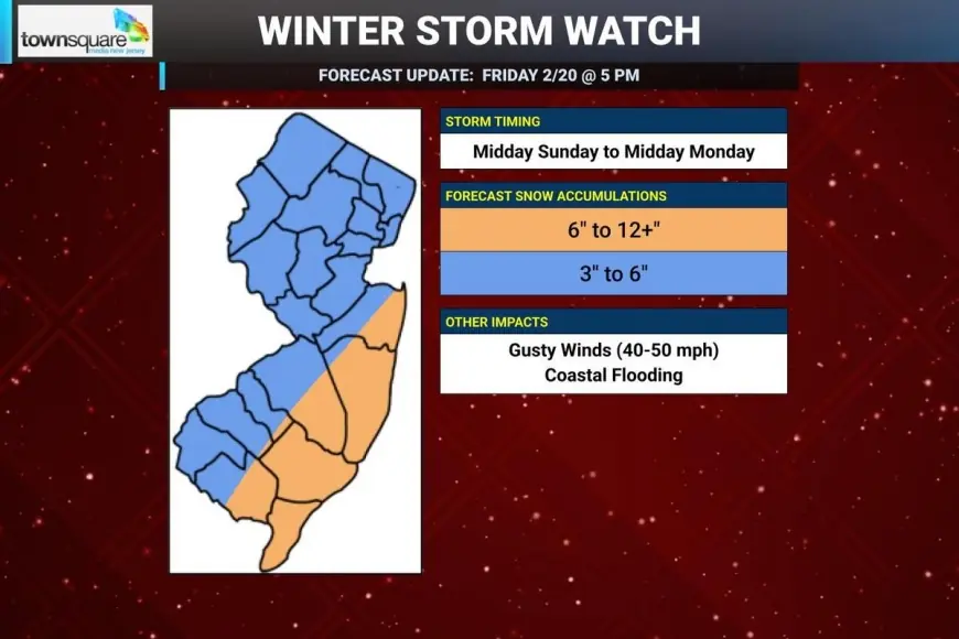
A winter storm watch was declared for all 21 counties of New Jersey, effective from 6 a. m. Sunday through 6 p. m. Monday ET, as forecast models now align on a coastal nor'easter that could bring double-digit snowfall and near-blizzard conditions to parts of the state. The move signals increasing confidence that hazardous winter weather will arrive this weekend and into Monday, posing risks to travel and coastal communities.
Winter Storm Watch details
The watch window runs from 6 a. m. Sunday through 6 p. m. Monday ET for every county in New Jersey. In New Jersey practice, a watch is issued when at least 5–6 inches of snow are expected; watches are typically updated to warnings or downgraded to advisories once a storm is within 24 hours of arrival. Forecast guidance has converged enough that forecasters now consider a complete miss unlikely for the state.
Expected impacts across New Jersey
Current forecasts call for significant snow for the Jersey Shore and possibly much of the state, with double-digit snowfall likely in some areas and the possibility of near-blizzard conditions. Heavy snow bands are expected to develop close to the coast, accompanied by strong winds and a threat of coastal flooding. Inland snowfall may be enhanced as a secondary disturbance, described in forecast discussion as an inverted trough, works in tandem with the main coastal low.
Forecast risks and timing uncertainties
Forecasters note several factors that could limit or concentrate snowfall. Initial mixing or rain at the storm onset — most likely in southern and coastal New Jersey — could reduce early accumulations before a changeover to snow. There is also expected to be a sharp cutoff between areas of heavy snow and more moderate totals; whether that cutoff falls on New Jersey soil is unclear at this time. Small shifts in the storm track of 30 to 60 miles would materially change local totals, and the storm would need to maintain an ideal coastal position and strength to deliver the more extreme "snow bomb" outcomes.
Practical implications and next steps
Roads and travel could become hazardous quickly, particularly in areas forecast to receive double-digit accumulations; the state’s already plowed streets and large plow piles from the previous storm may complicate clearing this round of heavy snow. The watch highlights that public safety and transportation officials, schools, and residents should prepare for significant impacts and monitor updated forecasts. If the system remains on the current track and timing, the watch will be re-evaluated and could be upgraded within 24 hours of the storm's arrival.
- Key takeaways: a winter storm watch is in effect for all 21 New Jersey counties; heavy coastal snow, strong winds, and coastal flooding are possible; initial rain/mix could occur in southern/coastal areas before a changeover to snow.