


Bloomington Tornado: Severe Weather Leaves Its Mark as Watch Is Extended Across Central Indiana
The Bloomington Tornado left tangible damage in and around the city while a tornado watch that had been covering much of central Indiana was extended before later expiring. The extension and subsequent warnings affected a wide swath of counties and coincided with multiple tornado warnings issued across the state.
Bloomington Tornado: Local damage and immediate impact
Tornado damage was reported in Bloomington at the Monroe County Airport, as well as to some homes and businesses. Sullivan County Emergency Management also reported damage to homes and cars caused by fallen trees. These impacts reflect the localized but serious effects of the storms that moved through the area.
Details about the full extent of damage, recovery operations, and assistance efforts remain limited. Recent updates indicate the tornado watch has expired; further on-the-ground assessments may clarify the scale and recovery needs.
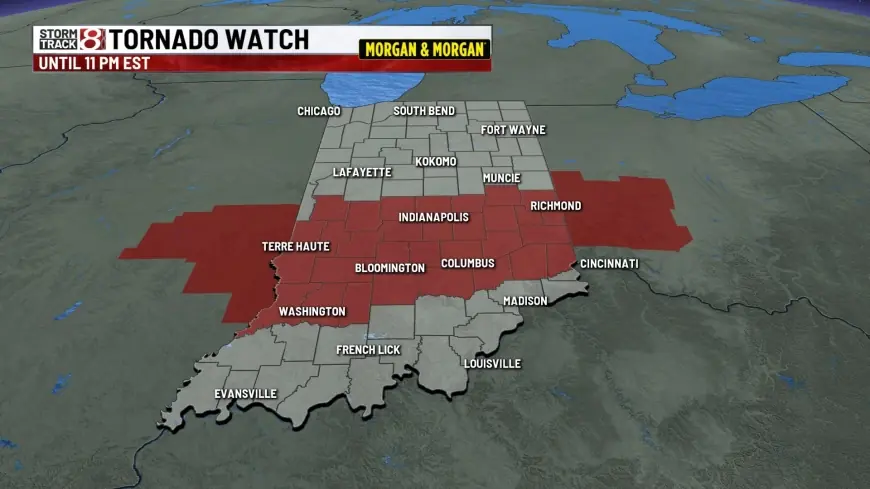
Tornado watch extended across central Indiana
A tornado watch that had been expected to end at 9 p. m. was extended to 11 p. m. The extended watch added Indianapolis and a list of central Indiana counties to the watch area, expanding the period during which severe weather was possible.
- Counties included in the extended watch: Bartholomew, Brown, Clay, Daviess, Decatur, Greene, Hancock, Hendricks, Henry, Jackson, Jennings, Johnson, Knox, Lawrence, Marion, Martin, Monroe, Morgan, Owen, Parke, Putnam, Rush, Shelby, Sullivan and Vigo.
- A broader initial watch area earlier included many additional counties across southern Indiana, and parts of Kentucky and Illinois were also in the watch area.
The initial tornado watch was issued shortly after noon, with at least a dozen tornado warnings later issued across the state. Additional counties were added to the watch area at approximately 4: 20 p. m. and again at about 6: 21 p. m., while some counties along the Ohio River — Clark, Floyd and Harrison — were removed from the watch area as of about 6: 21 p. m.
What happened during the warnings and what comes next
At least 12 tornado warnings were issued in the state while the watch was active, signaling multiple rotating storms or storm cells of concern. The watch extension and the subsequent warnings indicate a period of heightened tornado risk across much of southern and central Indiana during the afternoon and evening.
With the watch now expired, attention will move to damage assessment, tree and debris removal, and any necessary support for affected residents and businesses. Local emergency management authorities have noted damage to property and vehicles in affected counties; additional on-site evaluations will determine recovery timelines and resource needs.
Context and public safety reminders
The sequence of events — an initial watch, multiple county additions and removals, an extension of the watch window, and numerous warnings — underscores how rapidly conditions evolved. Residents in impacted counties experienced direct effects, with the Bloomington Tornado leaving damage near the Monroe County Airport and in nearby neighborhoods and businesses.
Residents are advised to monitor local emergency communications for recovery guidance and any further safety notifications. Details remain subject to updates as assessments continue and officials compile a more complete picture of storm impacts.