


Wind Advisory Puts Michigan Neighborhoods on Alert as Gusts Up to 45 mph Threaten Trees, Travel and Local Power
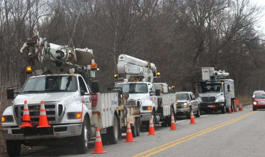
The immediate impact will be felt by drivers, homeowners and municipal crews as a wind advisory moves across broad swaths of Michigan. The wind advisory calls for sustained southwest winds with gusts up to 45 mph that can toss unsecured objects, bring down limbs and cause a few power outages; the strongest gusts are expected during afternoon hours. If you travel or manage property in the warned areas, plan for disruption.
Wind Advisory impact: who faces the biggest disruption and why it matters now
Here’s the part that matters: high‑profile vehicles will find some roads challenging, yard furniture and lightweight outdoor items can become hazards, and crews may be responding to scattered tree and power incidents through the evening. Municipal services and residents in the advisory zones should expect an elevated workload and prepare to secure outdoor items. If you rely on local power-sensitive equipment, consider contingency plans for short outages.
Event details and regional differences
The advisory covers different sets of counties with slightly different start times and identical maximum gust expectations. In areas designated as southwest and south central Michigan, the advisory is in effect from 7 a. m. to 9 p. m., with southwest winds of about 15 to 30 mph and gusts up to 45 mph. For parts of southeast Michigan, the advisory runs from 10 a. m. to 9 p. m., with southwest winds generally in the 15 to 25 mph range and gusts also up to 45 mph.
- Counties included in the southwest/south central footprint include Ottawa, Kent, Ionia, Clinton, Allegan, Barry, Eaton, Ingham, Van Buren, Kalamazoo, Calhoun and Jackson.
- Southeast coverage lists Genesee, Lapeer, Lenawee, Livingston, Macomb, Monroe, Oakland, Shiawassee, Washtenaw and Wayne Counties.
- Major cities named in the advisories include Grand Rapids, Lansing, Kalamazoo, Battle Creek, Jackson, Holland and Grand Haven among others.
Winds will ramp up through the morning with the afternoon hours most likely to produce the strongest gusts. Gusty conditions are expected to blow around unsecured objects, and tree limbs could be blown down; a few power outages may result. Drivers are warned that winds this strong can make driving difficult, especially for high‑profile vehicles, and extra caution is advised.
- 7 a. m. –9 p. m.: advisory window for portions of southwest and south central Michigan.
- 10 a. m. –9 p. m.: advisory window for much of southeast Michigan, including Macomb County and neighbors.
- Afternoon hours: the period most likely to produce peak gusts up to 45 mph.
What’s easy to miss is that both advisories put the same peak gust figure on the table, which raises the odds of downed limbs and isolated outages across multiple regions at the same time. The real question now is how local crews will prioritize calls if multiple areas report damage during the afternoon surge.
- Secure or store outdoor furniture, trash cans and lightweight equipment before winds increase.
- Expect possible short, localized power interruptions—have basic supplies ready (lights, phone chargers, a battery lamp).
- If driving, reduce speed and give extra room to high‑profile vehicles; crosswinds can push trailers and tall trucks.
- Municipal and utility responders should prepare for multiple service calls during the afternoon and evening.
If you’re wondering why this keeps coming up, it’s because gusts to 45 mph are explicitly mentioned for both the southwest/south central and southeast advisories, creating simultaneous risk across many community footprints. Recent notices emphasize securing items and exercising extra driving caution rather than evacuation or wide area closures.
The larger signal is practical: treat this as a day for precaution rather than panic. Small actions—tying down a trampoline, stowing patio furniture, delaying nonessential high‑profile hauling—can prevent the most common wind‑related headaches and reduce call volume for emergency crews.
Schedule note: timing and coverage are set in the advisories and are subject to change; monitor local communications for updates.