


Flood watch issued for parts of Pennsylvania as ice-jam threat raises runoff concerns
The National Weather Service issued a flood watch Thursday at 11: 02 a. m. ET and again at 11: 08 a. m. ET for additional areas, placing many central and western Pennsylvania counties under heightened alert from 1 p. m. Thursday until 1 p. m. Friday ET. Officials warn that ice jams and rapid runoff from forecasted precipitation could raise water levels in rivers, creeks and low-lying areas.
Where the flood watch applies
The watch covers a broad swath of counties. Included are Cambria, Blair, Huntingdon, Somerset, Bedford and Fulton counties in the central region; and Venango, Forest, Lawrence, Butler, Clarion, Jefferson, Armstrong, Westmoreland, Fayette and Indiana counties, with specific mention of Westmoreland Ridges, Fayette Ridges and higher elevations of Indiana.
The advisory window runs from 1 p. m. Thursday until 1 p. m. Friday ET. Residents in flood-prone neighborhoods, those near rivers and streams, and people camping or traveling through low-lying corridors should stay alert for changes to the situation and be prepared to take quick action if flood warnings are later issued.
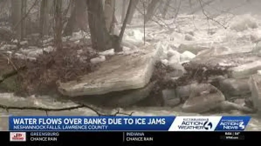
Why officials issued the watch and what to expect
Forecasters cite two main hazards: ice jams and excessive runoff. Ice jams form when chunks of river ice accumulate and create temporary blockages. When these jams release or when melt and rain push additional water downstream, sudden rises in water level can occur. Excessive runoff from rain, combined with frozen or saturated ground, can lead to rapid rises in creeks, streams and rivers.
A brief primer on alert levels: a flash flood warning means a flash flood is imminent or occurring and immediate movement to higher ground is required. A flood warning indicates flooding is imminent or already happening. A flood advisory means flooding is possible at a level that could inconvenience residents even if it doesn’t reach warning severity. A flood watch, as in this announcement, signals that conditions are favorable for flooding but does not guarantee it will happen.
Practical safety steps for residents
Officials stress preparation: move to higher ground if you are in a flood-prone area or camping in low-lying terrain. If local authorities issue an evacuation order, leave promptly and secure your home by locking doors. If time allows, disconnect utilities and unplug appliances to reduce electrical hazards during flood conditions.
Never enter water near submerged electrical outlets or cords; if you hear buzzing, snapping or see sparks, evacuate immediately. Avoid walking through moving water—just 6 inches of fast-moving water can knock an adult off their feet. Never drive through flooded roadways: as little as 12 inches of rapidly flowing water can carry away most vehicles.
If you become trapped by rising water, move to the highest point available and call 911 for emergency assistance. Stay tuned to later forecasts and be ready to act if flood warnings are posted for your area.
With temperatures and precipitation changing quickly this time of year, the combination of melting ice and rain can produce fast-changing conditions. Residents should monitor local updates and prioritize safety when navigating roads and low-lying areas during the watch period.