


Central NY Snowfall: Discover Areas with Highest Early Snow Totals (Map)
The snowfall in Central New York has reached significant levels, affecting several counties. The region is currently under a winter storm warning, with heavy accumulations reported in the Southern Tier and Finger Lakes.
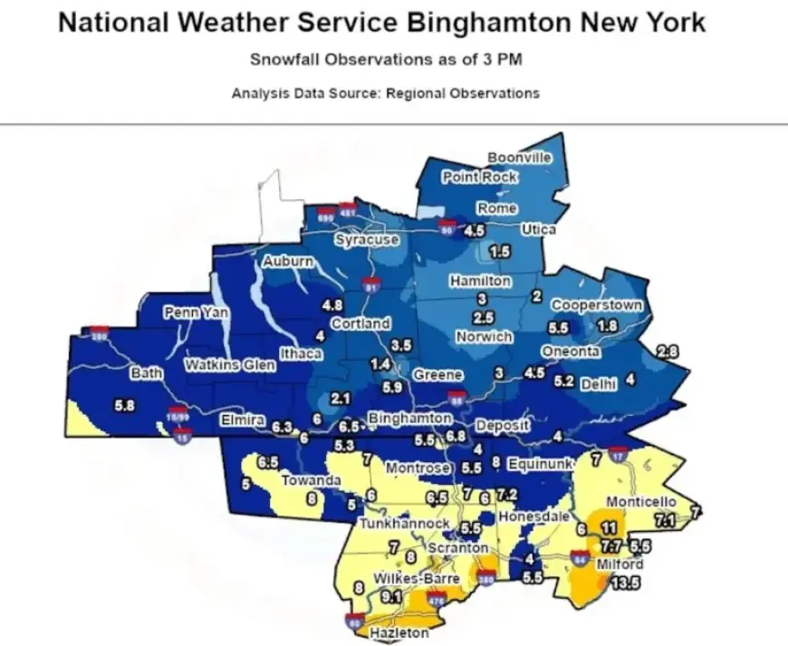
Snow Accumulation Reports
As of 3 p.m., several areas have recorded impressive snow totals:
- Sullivan County: 8 inches near Kiamesha
- Broome County: 6.7 inches near Vestal; 5.9 inches at the NWS office in Binghamton
- Tioga County: 6.5 inches in Tioga Terrace and Apalachin
- Steuben County: 5.8 inches in Jasper
- Delaware County: 5.2 inches in Franklin
- Cayuga County: 4.8 inches near Locke
- Onondaga County: 3.8 inches in Fairmount; 2.5 inches near East Syracuse
Forecast and Weather Alerts
The National Weather Service warns of further heavy snowfall expected from Sunday afternoon into the evening. Some areas may experience snowfall rates exceeding 2 inches per hour. This indicates a continued risk for hazardous conditions.
Snowfall is projected to diminish on Sunday evening, although temperatures will remain low, hovering between the upper single digits and the teens. Additionally, northwest winds could gust up to 35 mph on Monday, creating further challenges with blowing and drifting snow.
Residents are advised to stay updated on weather conditions and heed local advisories as the storm progresses.