


Extreme Cold Warning in Texas: Austin, Houston and DFW brace for hazardous roads and scattered power outages
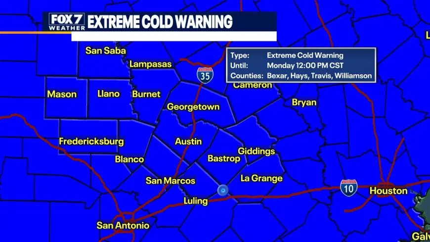
An extreme cold warning across parts of Texas is shifting the biggest risk from “how much snow” to everyday survival logistics: whether it’s safe to drive right now, how long icy bridges stay slick after sunrise, and whether neighborhood power stays steady through repeated hard-freeze nights. With freezing temp readings spreading from North Texas into Central and Southeast Texas, road conditions near me can change block to block—especially around overpasses—while the electric grid faces its most delicate test when demand spikes at the coldest hours.
Mini timeline (current event window)
-
Jan. 24: Winter storm impacts expand across North and Central Texas; travel hazards increase in the DFW weather area as sleet and snow accumulate.
-
Jan. 25 (Sunday): Ice risk grows farther south; Houston weather turns wintry with freezing rain and slick highways in parts of the metro.
-
Jan. 24–27: ERCOT keeps a Weather Watch in place as subfreezing temperatures and frozen precipitation raise outage potential.
-
Overnight into Monday: Refreeze becomes the main threat—wet pavement can turn to black ice after dark even if daytime temperatures briefly recover.
Travel safety is the immediate crisis: TxDOT road conditions can flip in minutes
For most drivers, the question isn’t “Texas weather” in the abstract—it’s “Texas road conditions” right now. Ice tends to form first on bridges, elevated ramps, and overpasses, where air circulates above and below the roadway. Even a thin glaze can cause multi-car crashes because traction disappears without warning.
TxDOT has urged drivers to stay off the roads where possible during icy periods and reminds Texans that closures are typically enforced by law enforcement while transportation crews focus on treatment and monitoring. If you must drive, treat txdot road conditions updates as a go/no-go checklist before leaving:
-
Slow down early (braking on ice is usually too late).
-
Avoid overpasses if an alternate route exists.
-
Assume shaded lanes refreeze after sunset, even if the afternoon melted slush.
-
Keep extra distance—several car lengths more than usual.
-
If you start to slide: ease off the gas, steer gently, avoid hard braking.
People searching “txdot road conditions” are often really looking for the state’s DriveTexas status and camera snapshots. Use the official map and hotline tools, and check local incident maps in major metros. Don’t rely on a single screenshot that’s an hour old.
Houston weather: ice on roads, hard freeze nights, and a Monday refreeze risk
Houston weather has turned sharply colder, and the key word is ice. Reports of slick conditions on major corridors and frontage roads have been tied to freezing rain and sleet in parts of the metro—especially north of the urban core. The Houston weather forecast points to a cold Sunday with temperatures hovering near or below freezing in spots, then dropping deeper overnight. That matters because wet roads can freeze again after dark, turning “mostly fine” surfaces into patchy black ice by early Monday.
Practical reality for “weather Houston” searches:
-
If your route includes elevated ramps, plan for delays or avoid driving.
-
If you’re near the north and northwest suburbs, the icing risk is typically higher.
-
A brief midday improvement can be misleading; the dangerous window often returns after sunset.
Austin weather: a cold corridor where timing matters more than totals
Austin weather is caught in a transition zone where small temperature differences decide whether precipitation stays as cold rain or becomes freezing rain. That makes “austin weather” and “austin tx weather” forecasts unusually sensitive to neighborhood-level conditions. In this setup, the safest assumption is that elevated roadways and untreated secondary streets are riskier than main lanes, and the most hazardous period is often late night through early morning when temperatures bottom out.
For “is it safe to drive right now” in the Austin area:
-
If air temperature is at or below freezing, treat any moisture as potential ice.
-
Leave extra time and avoid high-speed connectors.
-
If you can delay until late morning, do it—especially after a night of freezing temp readings.
DFW weather and Fort Worth weather: sleet-and-snow impacts plus power interruptions
North Texas has been dealing with the more classic winter-storm mix: sleet, snow, and bursts of freezing rain. Dallas Texas weather and Fort Worth weather conditions can vary quickly, and the combination of accumulation plus refreeze creates rolling hazards even after plows and treatments.
Power outages Texas-wide have been reported in the tens of thousands during this event window, with the highest risk in areas seeing ice loading on lines and tree limbs. That’s where “ercot power outage” searches surge: people want to know whether the grid is failing or whether localized damage is knocking out neighborhoods.
ERCOT: weather watch conditions, grid stability, and why outages can still rise
ERCOT has issued a Weather Watch for Jan. 24–27 due to forecasted below-freezing temperatures and the possibility of frozen precipitation. A weather watch doesn’t mean the grid is collapsing; it signals that conditions could stress generation and demand and that operators are monitoring system performance more tightly.
Two things can be true at once:
-
The ERCOT system can remain operationally stable at the statewide level.
-
Localized outages can still climb because ice and wind damage distribution lines, transformers, and equipment outside the core generation balance.
If you’re tracking “ercot texas power outages,” focus on your utility’s outage map and restoration estimates, and prepare for overnight interruptions during the coldest hours.
Quick prep checklist as temperatures drop
-
Charge devices and power banks before bedtime.
-
Set faucets to a slow drip where freezes are hard.
-
Keep blankets and layered clothing accessible in case of short outages.
-
If you use space heaters, keep them clear of combustibles and never run generators indoors.
Texas weather in this pattern is less about a single “storm day” and more about repeated freeze–thaw–refreeze cycles. The safest strategy is simple: minimize travel until roads are treated and temperatures rise, and plan for scattered outages even if the broader grid holds.