


AccuWeather Boston forecast: a long-duration snowstorm tightens its grip, with dangerous travel and widespread Monday closures
Boston’s winter storm isn’t a quick hit—it’s the kind that steadily turns routine errands into high-risk decisions. Snow that starts manageable can stack into near-continuous accumulation, and that’s where accidents, stranded vehicles, and delayed emergency response begin to climb. The key change over the next 24–36 hours isn’t just “more snow,” but the combination of heavy bursts, falling visibility, and a sharp temperature drop that can lock untreated surfaces into ice-hard ruts.
The uncertainty isn’t whether it snows—it’s where the heaviest band parks
AccuWeather’s Boston-area outlook and federal winter storm alerts are aligned on the broad message: heavy, persistent snow through Sunday into Monday, with totals high enough to make travel “extremely difficult” at times. The remaining uncertainty is the storm’s most punishing stripe—where snowfall rates peak and whether Boston proper lands closer to the low teens or pushes toward the upper end of the range.
That matters because the difference between 12 inches and 18 inches isn’t “a little more shoveling.” It’s the difference between passable side streets and a city that effectively pauses. It also changes plow timing, public transit reliability, and the odds that power line issues crop up where wind and heavy, clinging snow overlap.
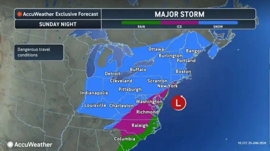
Boston weather today and tomorrow: timing, temperatures, and snow totals
Sunday (Jan. 25): Snow becomes heavier at times as the day goes on, with road conditions deteriorating fast once accumulation outpaces treatment. Daytime highs sit in the upper 20s, keeping the snow mostly fluffy—easy to blow around, harder to see through.
Sunday night: Snow continues much of the time. This is often when totals “jump,” because traffic thins out, plows can’t keep every neighborhood clear, and temperatures stay cold enough that compacted snow turns slick.
Monday (Jan. 26): Intermittent snow continues with additional accumulation possible, plus periods of breeze that can lower visibility and drift snow back across cleared lanes. By Monday night, colder air pushes in hard, with lows dropping into the single digits—setting up bitter conditions for the Tuesday morning commute even after the snow ends.
Current storm-total range most residents should plan around
A storm warning covering much of eastern and central Massachusetts calls for roughly 12–20 inches of total accumulation by Monday evening in the broader region. For practical planning, treat 12 inches as the “best-case that still disrupts life,” and 20 inches as the “expect delays, stranded cars, and slow plowing on secondary roads” scenario.
Here’s a planning map in words—not a guarantee, but a realistic way to think about totals:
-
Boston / immediate metro: 12–18 inches (with localized higher pockets if a heavy band stalls)
-
I-95 belt & inner suburbs: 12–20 inches
-
Worcester Hills / higher terrain: 14–20+ inches
-
Cape & Islands: Lower totals possible if mixing or wind reduces accumulation, but conditions can still be hazardous
Temperatures across New England pivot colder after the storm’s main phase, with daytime highs settling into the teens and low 20s in many spots midweek—cold enough that leftover slush won’t “melt off,” and untreated sidewalks refreeze nightly.
School closings across Massachusetts: what’s known right now
Many Massachusetts school districts have already announced Monday closures ahead of the worst travel window, and the list is expanding town by town. The pattern is familiar in long-duration storms: districts that close early encourage families to finalize childcare plans before conditions become dangerous, while a smaller group waits for midday updates as snowfall bands sharpen.
Because decisions vary by district, the most reliable check remains your local school district communications and your town or city alerts for municipal buildings, parking bans, and trash/recycling delays. If you’re in a household juggling work and childcare, assume Monday will be disrupted and plan as if schools are closed unless you receive a direct “open” notice.
A mini timeline to plan moves and avoid the worst windows
-
Sunday late morning through evening: Snow intensifies; visibility drops at times; driving becomes steadily riskier.
-
Sunday night: Near-continuous snow keeps roads from “catching up,” especially away from main routes.
-
Monday daytime: Additional snow keeps travel difficult; plowing improves some corridors while side streets lag.
-
Monday night into Tuesday: Temperatures plunge; refreeze risk spikes; any untreated wet spots turn into hard ice.
Quick actions that reduce risk (and a lot of regret)
-
Avoid “one last trip” after heavy snow sets in. Most weather-related crashes happen in the transition from light accumulation to heavier rates.
-
Park with plows in mind. If your town issues a parking ban, treat it as a safety measure—not a suggestion.
-
Charge devices and prep for delayed services. Even without major outages, storms like this can slow everything: deliveries, towing, public transit, and emergency response.
-
Shovel in rounds, not once. Clearing every few inches is easier and safer than tackling a full storm total in one go—especially before the cold snaps tighter.
Boston’s snowstorm is already a high-disruption event. The final totals will come down to where the heaviest snowfall band lingers the longest, but the impacts are already clear: difficult travel into Monday, widespread school closures, and a sharp turn to deep cold that will keep the region dealing with the storm’s leftovers well into the week.