How Much Snow Is Expected on Sunday in NJ and Long Island? Latest Snow Forecast as Arctic Air Deepens

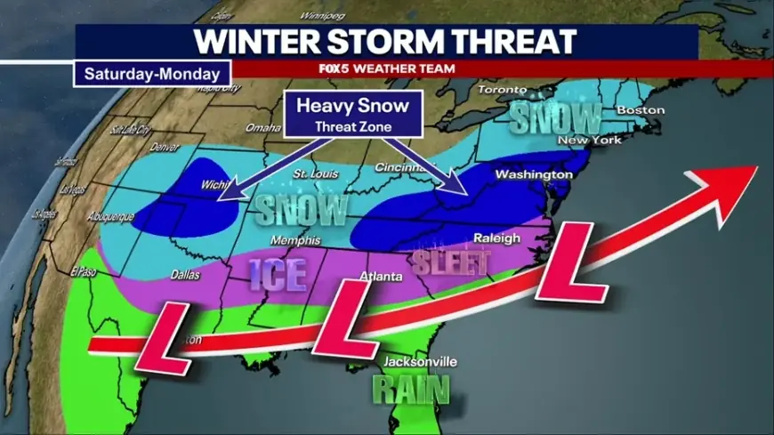
Sunday, January 25, 2026 is shaping up as the first truly disruptive snow day for parts of New Jersey and Long Island this week, not because it looks like a historic blizzard everywhere—but because the cold will be intense and the snow will stick fast. Current projections point to a plowable snowfall for much of the NYC metro, with a realistic range of roughly 2–6 inches in many neighborhoods, while a narrower corridor could land higher totals if the steadiest snow band sets up overhead for several hours.
The big message for planning: expect the worst travel window late Sunday into early Monday, when snow rates can briefly increase and untreated roads turn slick quickly in single-digit wind chills.
-
Most of the region is tracking toward a few inches of snow on Sunday, with locally higher totals where heavier bands linger.
-
The cold is severe, so even moderate snowfall can create icy, snow-packed roads.
-
The main snow window favors late Sunday through early Monday, with cleanup complicated by refreeze.
-
Final totals remain sensitive to the storm track; small shifts can change who gets 2 inches vs. 6+ inches.
-
Wind and powdery snow could reduce visibility at times even without extreme totals.
NJ weather: Sunday snow totals by area
For New Jersey, the most consistent signal right now is a general 2–5 inch type event for a large portion of North and parts of Central Jersey, with the possibility of pockets reaching the higher end if the banding is stronger than expected. The cold air will already be in place, so accumulations begin quickly once snow starts.
Most likely Sunday ranges (storm-total guidance, not exact):
-
North Jersey (including the NYC-adjacent corridor): about 2–5 inches
-
Central Jersey: about 2–5 inches, with some towns closer to 1–3 inches if the steadiest snow stays north/east
-
South Jersey: a wider spread remains possible, especially closer to the coast and I-95-adjacent zones, where totals could trend higher if the storm tracks a bit closer
Because temperatures are expected to stay in the teens/low 20s, there’s little melting during the event. That’s why a 3–4 inch forecast can behave like a bigger storm in terms of road conditions.
Long Island snow forecast: how many inches on Sunday?
Long Island is also in line for a plowable snowfall Sunday, with a broad expectation of 2–5 inches for many communities. The island can see sharp east–west gradients, so totals may differ noticeably between central areas and the East End depending on where the coastal-front boundary sets up and how long steadier snow persists.
Most likely Sunday ranges:
-
Western/central Long Island: 2–5 inches
-
East End: could run lower or higher depending on band placement and any brief mixing near the coastline
If the air stays cold enough throughout, snow will be light and “fluffier,” meaning it can drift more easily in gusty conditions.
Polar vortex forecast: why this storm may feel worse than the totals
Whether you call it “polar vortex” or simply an Arctic outbreak, the effect is the same: unusually cold air increases the impact of the snow. Salt and brine are less effective at very low temperatures, and any slush that forms can refreeze quickly. Wind chills will also make cleanup harder and increase the risk of frostbite for anyone shoveling for long periods.
In practical terms, the cold raises the stakes in three ways:
-
Roads ice faster and stay icy longer.
-
Snow stays powdery, so wind can blow it back onto cleared surfaces.
-
Overnight refreeze Sunday night into Monday can create black ice even after plows pass.
Timing: when will it snow on Sunday?
The most common timing scenario has snow developing late Sunday (often after midday in some areas), becoming steadier into the evening, then continuing into the overnight hours and tapering early Monday. The exact start time may vary by county, but the high-impact window for travel is most likely Sunday evening through Monday morning.
A short historical note: late January storms in the NYC metro often become “high-impact” events even with moderate totals when an Arctic air mass arrives first—because the snow sticks immediately and the post-storm refreeze turns leftover moisture into ice.
FAQ
Will it snow all day Sunday?
Not necessarily. Many scenarios favor a later start Sunday with steadier snow in the afternoon/evening, then lingering snow overnight into early Monday.
How many inches of snow are expected on Sunday in NJ?
A reasonable planning range is 2–5 inches for much of North/Central Jersey, with local pockets potentially higher if heavier bands set up.
How many inches are expected on Long Island Sunday?
Many areas are tracking 2–5 inches, with sharper neighborhood-to-neighborhood differences possible depending on band placement.
What’s the biggest uncertainty right now?
Storm track and banding. A shift of 30–60 miles can be the difference between a nuisance snowfall and a solid 6-inch event in any given town.
The next update to watch is how the storm’s core track settles Saturday into early Sunday. If guidance trends closer to the coast, totals can tick up quickly for NJ and Long Island. If it shifts farther south or east, totals come down—but the cold remains, and even a few inches can still deliver a difficult commute Monday morning.


