


Minnesota Faces Snow Showers Wednesday, Frigid Temperatures to Follow
Minnesota residents should prepare for snow showers and plummeting temperatures this week. A series of weather events will bring snow and frigid conditions.
Weather Forecast for Minnesota: Snow and Cold Temperatures
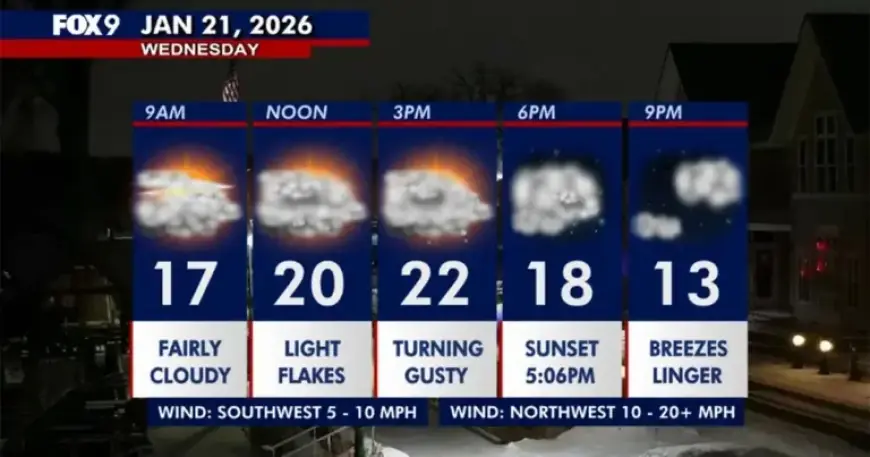
On Wednesday, Minnesota is expected to remain mostly cloudy. Light snow may occur throughout the morning and afternoon hours.
- Expected High: 22°F in the Twin Cities Metro
- Wind Gusts: Potentially reaching mid-40s mph in western Minnesota
These wind conditions could cause loose and fluffy snow to blow over roadways, resulting in dangerous driving conditions. A winter weather advisory is in place for western and southwestern Minnesota, effective until 6 p.m.
Overnight and Extended Forecast
As night falls, temperatures are expected to dip into the single digits, with lingering clouds and occasional flurries.
On Thursday, an influx of arctic air will cause temperatures to peak around 8°F before continuing to descend. Clouds will give way to some sun in the afternoon.
- Overnight Lows: Subzero teens expected on Thursday night
- Friday’s High: Approximately -8°F
- Saturday: Temperatures remain below zero
An extreme cold watch will be in effect from Thursday evening through Saturday morning across parts of Minnesota and Wisconsin. This warning is due to dangerously low wind chills and subzero temperatures.
Seven-Day Weather Outlook
Residents can expect continued cold weather, with the conditions worsening significantly over the weekend. Stay tuned for updates on Minnesota’s winter weather through Filmogaz.com.