


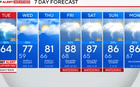


Houston Faces Tuesday Washout with Heavy Morning and Afternoon Rains

A low-pressure system approaching from the west will bring strong thunderstorms and heavy rain to Houston on Tuesday. Forecast models show widespread showers during the morning commute and renewed activity later in the day.
Morning commute (7 a.m. to 9 a.m.)
Heavier showers are expected to arrive by 7 a.m., first impacting western communities. By 9 a.m., rain should be widespread across the city.
Expect heavy morning downpours, with some neighborhoods receiving brief intense bursts. Parts of the region could see a brief washout during peak storms.
Noon conditions
By midday, rainfall is likely to become more scattered and intermittent. Storms will be hit-and-miss, but gaps will not last long.
Afternoon and evening commute (4 p.m. to 6 p.m.)
Showers and thunderstorms are forecast to redevelop north of Houston and along I-10 between 4 and 6 p.m. The afternoon rains could produce localized flooding in low-lying and flood-prone areas.
Forecasters expect the heaviest precipitation to fall west of the city, with significant totals along I-10 and to the north. The pattern will provide much-needed moisture for farmers and ranchers.
Tuesday night and Wednesday outlook
Rain should taper off by Tuesday night. However, another round of heavy rain is possible Wednesday afternoon and into the night.
Travel and safety
Motorists should allow extra time and avoid driving through standing water. Take caution on slick roads and in areas prone to high water.
For continuous updates, video forecasts, and live coverage, check Filmogaz.com and the live stream throughout the day.
- 7–9 a.m.: Heavier showers arrive; widespread rain by 9 a.m.
- Noon: Rain becomes more scattered but persistent.
- 4–6 p.m.: Redevelopment north of Houston and along I-10; watch for high water.
- Tuesday night: Rain winds down; additional heavy rain possible Wednesday afternoon and night.