


WNC Mountains Brace for Frost, Light Freeze Amid Wildfire Risks
A cold front on Sunday will return winter-like conditions to western North Carolina for a short time. Winds will ease and skies should clear, allowing temperatures to fall overnight.
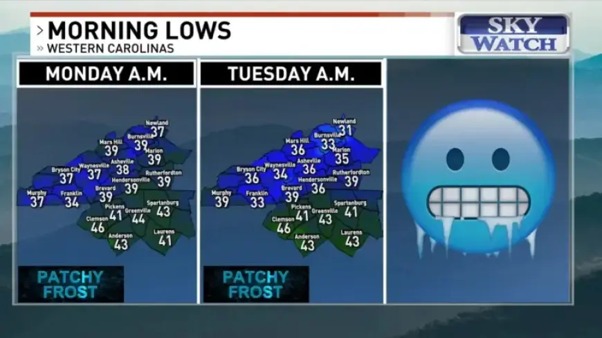
Morning lows are expected in the mid to upper 30s across the region by daybreak Monday. Gardeners should protect tender plants from freezing conditions.
Temperatures and Frost
Monday night will bring a further drop in temperatures. Many locations will fall into the lower to mid-30s.
Patchy frost is possible Monday morning in areas of western North Carolina. Frost will become more widespread across higher elevations later.
Freeze Watch for Northern Peaks
A Freeze Watch is scheduled to begin early Tuesday morning for parts of the northern mountains. Those zones could see a light freeze overnight.
Travel impacts are expected to be minimal. However, residents at higher elevations should take precautions for plants and outdoor pipes.
Wildfire Risk and Dry Conditions
Very dry air will dominate most of the week. That pattern raises wildfire concerns across the region.
Wildfire risks are forecast to be very high on Monday. Conditions grow more dangerous, with extremely high risk Tuesday through Thursday.
Rainfall and Outlook
Asheville Airport recorded just 0.05 inches from early morning rain. The small amount keeps the rainfall deficit growing.
The next chance for measurable rain arrives Saturday when a new cold front moves in. The front may stall, keeping rain chances through next Sunday.
- Expect mid to upper 30s by Monday morning.
- Lower to mid-30s likely Monday night.
- Freeze Watch starts early Tuesday for northern mountains.
- Wildfire risks remain very high to extremely high this week.
Filmogaz.com will continue monitoring the situation. Stay updated for any changes to watches or warnings.