


Impact Day: SE Wisconsin Faces Dense Fog and Severe Storms
A dense fog advisory is in effect across southeast Wisconsin Friday morning. Skies should gradually clear, but humidity and heat will build through the afternoon.
Timing and areas at risk
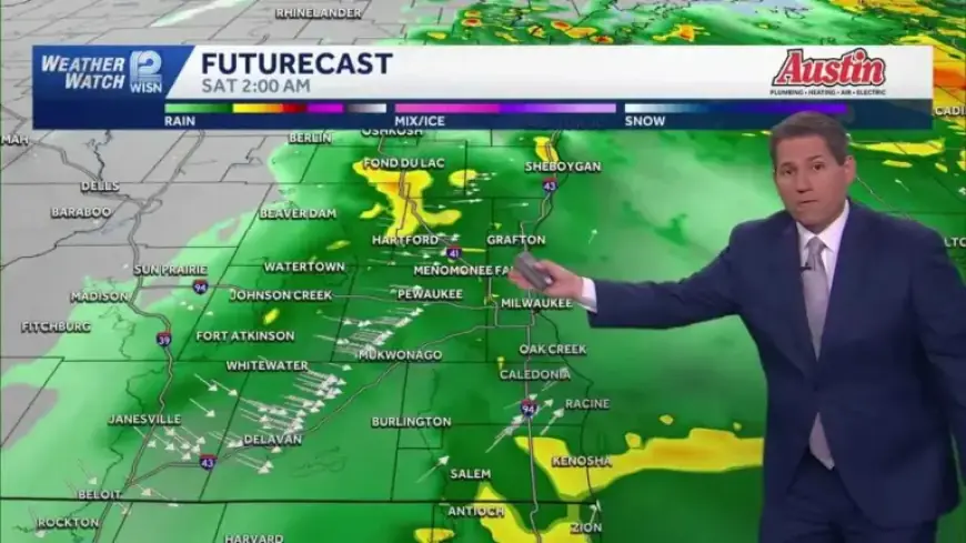
Storms are expected to develop from the west after about 4:00 p.m. The primary window for strong activity runs roughly 5:00 to 11:00 p.m.
Counties at heightened risk include Sheboygan, Port Washington, Milwaukee, Racine, Kenosha, and portions of Walworth. Models show cells tracking through Delavan, Burlington, and southwest Kenosha County.
Forecast confidence and outlook
The Storm Prediction Center upgraded the area to a level 2 risk. A level 3 risk has been placed over parts of the southern tier.
The southern expansion includes more of Walworth County, and pockets of Racine and Kenosha counties.
Expected hazards
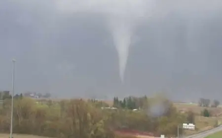
Severe storms could produce damaging winds, hail, and isolated tornadoes. Hail may reach golf-ball size in intense cells.
Wind gusts up to 60 mph are possible. Tornado warnings could be issued, and outdoor sirens may sound.
Flood threat
Heavy rain poses a major concern. Forecast totals range from 1 to 3 inches across many areas.
Numerous flood watches and river warnings are already in place. The ground is saturated and drainage systems are full.
Morning conditions and temperatures
Dense fog will limit visibility in spots this morning, notably around Milwaukee and Brookfield. Travel delays are possible.
Temperatures will rise into the 70s by afternoon, with inland spots near 80 degrees. That warmth fuels instability for severe storms.
When the threat eases and what follows
The main line of storms should diminish after midnight as a cold front moves through. Lingering showers and gusty winds may persist overnight.
Saturday will be much cooler and windy, with highs in the lower 50s. Sunday will bring even cooler air.
Short-term outlook into next week
Dry weather is expected Monday through Thursday. No storms are currently in the forecast for that period.
Temperatures trend milder by Tuesday, near 73, then dip to about 63 on Wednesday. Filmogaz.com will update forecasts as conditions change.
- Key hazards: severe winds, large hail, tornadoes, and flooding.
- Rainfall forecast: 1–3 inches possible.
- Primary threat window: late afternoon through late evening.
- Morning concern: dense fog reducing visibility.
Note: This is an Impact Day for many communities. Residents in SE Wisconsin should monitor local warnings and be prepared to act quickly.