


Boston Weather Forecast: Another Messy Storm Moves Into New England Thursday Afternoon
The latest boston weather forecast shows a messy storm moving into New England on Thursday afternoon (ET) and lasting into the early hours of Friday. This system brings a complex mix of snow, sleet, freezing rain and rain that threatens another disruptive evening commute and slippery travel across much of the region.
Boston Weather Forecast: timing and temperatures
After a prior storm left a glaze of ice for many southern New England communities, the region warmed into the upper 40s on a later day with snow melt in many spots. The new storm is expected to arrive after a dry start on Thursday, with precipitation entering Greater Boston by mid to late afternoon (ET).
Commuters can expect chilly conditions in the morning, with temperatures in the upper 20s under cloudy skies. Highs for the day will generally be cooler than the warm day that followed the earlier storm: most of the region has a good chance to reach the low 40s, while Boston and the immediate coast may remain in the upper 30s. Temperatures will fall toward or below freezing again after sunset, favoring a late shift back to wintry precipitation in many areas.
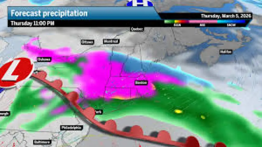
What the boston weather forecast means for precipitation and accumulations
This storm is not expected to be intense, but its mixed precipitation will create messy conditions. The wintry mix will include periods of snowflakes, sleet, and freezing rain, with more raindrops than snowflakes initially in Greater Boston. A transition to more snow is likely overnight in areas north of the Mass Pike and into northern New England.
- Greater Boston: Dry start and mostly cloudy. Highs in the upper 30s. Wintry mix moves in mid to late afternoon, setting up a messy night. Outcome is a coin-flip between a coating and a couple of inches after cold rain and sleet.
- Along the Mass Pike and northward (including Boston): Expect a coating to about 2 inches of snow in many locations.
- Northern New England: Plain snow is likely, with 2 to 4 inches possible.
- Northeast corner of Massachusetts and areas just north of Route 2: There is potential to see closer to 2 to 4 inches.
- Rain totals for southern New England: Between a half inch and about an inch by Friday morning.
Travel impacts, advisories and what to expect on the roads
Winter weather advisories for accumulating snow and sleet are in place for much of the region beginning Thursday evening and lasting into the start of Friday. The period of wintry mix Thursday evening into early Friday will bring patchy ice and widespread sleet across southern New England, creating slippery conditions away from the immediate coast.
Key travel notes:
- Morning commutes on Thursday should be mostly dry for many areas, with precipitation largely arriving after the workday begins.
- Plan for extra time for the evening commute on Thursday: mid to late afternoon onset of wintry mix in Greater Boston could produce another messy trip home.
- Expect patchy ice and sleet across southern parts of the region Thursday evening into early Friday, especially inland; coastal areas are less likely to see as much icing.
Outlook and caveats
Guidance might change a bit as the system approaches. The current picture favors mixed precipitation for most of Massachusetts into southern Vermont and New Hampshire, with plain snow sticking to northern New England. Some locations that begin with rain or sleet could flip to snow overnight, including parts of Boston.
Forecast details such as precise changeover lines and exact accumulation totals remain subject to adjustment as the storm draws nearer. Travelers should monitor updates throughout Thursday (ET) and prepare for slippery conditions Thursday night into early Friday.