


Tropical Cyclone Horacio marks a high-water benchmark for 2026 forecasting and marine safety
Why this shift matters now: tropical cyclone horacio became the world’s first Category 5 tropical cyclone of 2026, and forecasters expect its peak intensity to be followed by steady weakening — a development that changes immediate marine risk, informs short-term warnings for islands, and adds to the early-season intensity signal for the year. The storm’s rise and projected decay affect shipping, fisheries and coastal exposure to high-energy swells while remaining distant from major land centers.
Tropical Cyclone Horacio: immediate consequences for marine interests and warnings
Here’s the part that matters: Horacio’s surge to Category 5 strength elevated marine hazards even as the system stayed far from mainland coasts. Warnings and advisories focused on sea state, with explicit caution for fishermen, pleasure-craft operators, and anyone using local beaches or lagoons. Heavy swell alerts and Class 1 cyclone warnings were issued for nearby island territories while the storm tracked away and weakened.
Event details and intensity estimates
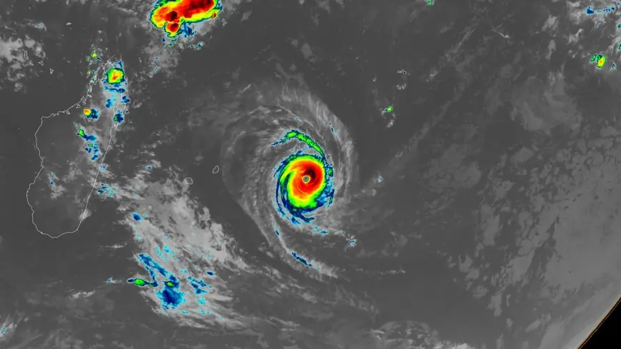
Tropical Cyclone Horacio intensified to Category 5-equivalent status over the central Southwest Indian Ocean east of Mauritius on February 22, 2026, and reached the world’s highest measured intensity for 2026 between February 22 and 23. Peak estimates include 1-minute sustained winds near 260 km/h (160 mph) and a peak headline figure of 160 mph (260 km/h). Regional 10-minute estimates placed sustained winds around 230–240 km/h (140–150 mph) with gusts near 280–300 km/h (175–185 mph) and central pressure near 910 hPa. Satellite and infrared imagery showed a symmetrical eye and strong convective bands at maximum strength.
- Development: originated from a low-pressure disturbance east of Rodrigues Island on February 18 and was named the next day.
- Rapid intensification: achieved a very intense status by February 22 after roughly 48 hours of intensification over warm waters with favorable upper-level outflow.
- Peak timing: reached Category 5 peak on February 23 (noted as Monday afternoon) and showed highest global intensity for the year during February 22–23.
Warnings, local impacts and sea-state details
Outer rainbands delivered periods of rain and gusty conditions to Rodrigues Island, where observed winds approached 100 km/h (60 mph) and seas exceeded 6–8 m (20–26 feet). A Class 1 Cyclone Warning for Mauritius-area waters remained in effect until February 23, when it was lifted as the system moved away. A Heavy Swell Warning for Rodrigues was issued at 04: 30 local time (00: 30 UTC) on February 24 and valid until 04: 00 local time (00: 00 UTC) on February 25. Warnings emphasized high-energy swells of roughly 7 m (23 feet) beyond reefs and the potential for waves to affect lagoons and low-lying coastal areas, particularly at high tide. Officials strongly advised against venturing to sea while warnings remained active, and no major damage or casualties were reported in the affected islands.
Forecast trajectory and weakening outlook
Forecast assessments indicated the cyclone had likely peaked and would weaken as it moved southward over progressively cooler waters and into higher wind-shear environments. At 06: 00 UTC on February 24 Horacio’s center was about 315 km (196 miles) southeast of Rodrigues and continuing south while weakening. Forecasters expected the system to transition to a post-tropical state within roughly 48 hours as it tracked into open ocean. Meteorologists noted at 07: 32 UTC on February 24 that environmental conditions were set to deteriorate, with increasing vertical wind shear partially offset by strong upper-level divergence and an outflow channel to the southeast. The final official forecast text in the provided account ended mid-sentence and is unclear in the provided context.
Historical context and wider season signals
Horacio is the Southern Hemisphere’s first Category 5 since Cyclone Errol reached that status off the coast of northwestern Australia on April 16, 2025. Over the 1990–2025 span the average yearly global number of Category 5 storms was 5. 3, and five Category 5 systems were recorded in 2025: Hurricanes Melissa, Erin, and Humberto in the Atlantic; Typhoon Ragasa in the Northwest Pacific; and Cyclone Errol in the South Indian Ocean. Analysts also noted that climate change is expected to increase the proportion of tropical cyclones that reach Category 4 and 5 strength, a factor cited as relevant when placing Horacio in seasonal and multi-year context.
What’s easy to miss is that the classification applied in the Southwest Indian Ocean—"Very Intense Tropical Cyclone"—is the basin’s top rating and is rare, typically appearing only once or twice per season. That rarity shaped local warnings and the decision thresholds for maritime advisories.
- Key takeaways: rapid summary bullets
- Horacio reached Category 5 strength (160 mph / 260 km/h) and was the first Category 5 of 2026.
- Peak estimates include 10-minute winds of about 230–240 km/h and central pressure near 910 hPa; 1-minute estimates near 260 km/h.
- Storm developed from a disturbance east of Rodrigues on Feb 18, named Feb 19, and intensified rapidly by Feb 22.
- Warnings concentrated on high swells (up to ~7 m / 23 ft beyond reefs), dangerous sea conditions, and shore impacts for Rodrigues and nearby islands; no major damage reported.
- Forecasts projected steady weakening and a post-tropical transition within about 48 hours as the cyclone moved south into cooler, higher-shear waters.
If you’re wondering why this keeps coming up in early-season reports, the event aligns with the climatological peak of the Southern Hemisphere cyclone season (February–March), when sea-surface temperatures and monsoonal outflow patterns favor rapid intensification. High-resolution imagery used in assessments included views from Himawari-8 and satellite datasets attributed to EUMETSAT/Meteosat-9 and RAMMB/CIRA, which illustrated Horacio’s symmetrical eye and convective structure at peak strength.
Author note: analysis contributions in the provided coverage included commentary from Jeff Masters, Ph. D., a former hurricane scientist with the NOAA Hurricane Hunters from 1986–1990 who left that role after a near-fatal flight into Category 5 Hurricane Hugo. The byline date present in the material was February 23, 2026.
The real question now is how the post-peak decay plays out: forecasters have a clear weakening trend in their short-term outlooks, and confirmation will come from sustained decreases in measured winds, rising central pressure, and the expected loss of a warm-core structure as the system crosses cooler open waters.