


Tropical Cyclone Horacio becomes world’s first Category 5 of 2026
tropical cyclone horacio reached Category 5 strength during a rapid intensification event late in February, topping out with sustained winds of 160 mph (260 km/h) over the remote South Indian Ocean and becoming the first Category 5 tropical cyclone of 2026.
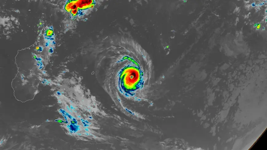
Tropical Cyclone Horacio peaks in the South Indian Ocean
Horacio reached maximum sustained winds near 160 mph (260 km/h) as it intensified to a Category 5-equivalent system in the central Southwest Indian Ocean, east of Mauritius. Some analyses timestamped its Category 5 intensification on February 22, while other assessments placed that milestone on the afternoon of February 23.
Rapid intensification from a disturbance east of Rodrigues
The system developed from a low-pressure disturbance east of Rodrigues Island on February 18 and was named by RSMC La Réunion on February 19. Over the following 48 hours Horacio underwent rapid intensification over warm waters, reaching a very intense status by February 22 and exhibiting a symmetrical eye and strong convective bands visible in Himawari-8 imagery.
Multiple intensity estimates and basin classification
At its peak between February 22 and 23, RSMC La Réunion estimated 10-minute sustained winds of about 230–240 km/h (140–150 mph) with gusts near 280–300 km/h (175–185 mph) and a central pressure of roughly 910 hPa. The Joint Typhoon Warning Center assessed 1-minute sustained winds near 260 km/h (160 mph), placing Horacio at Category 5 on the Saffir–Simpson scale. RSMC La Réunion classified the system as a "Very Intense Tropical Cyclone, " the highest rating in the Southwest Indian Ocean basin, a designation that is rare and typically occurs once or twice per season.
Rodrigues and Mauritius warnings, swells and coastal effects
Outer rainbands brought periods of rain and strong gusts to Rodrigues, where winds reached around 100 km/h (60 mph) and seas exceeded 6 to 8 m (20 to 26 feet). Mauritius Meteorological Services maintained a Class 1 Cyclone Warning until February 23 and then lifted it as the system moved away. A Heavy Swell Warning for Rodrigues was issued at 04: 30 LT (00: 30 UTC) on February 24, valid until 04: 00 LT (00: 00 UTC) on February 25, with forecasters warning of swells of about 7 m (23 feet) beyond the reefs and waves that could break along low-lying coastal areas at high tide. Fishermen, pleasure-craft operators, and the public were strongly advised not to venture at sea or along beaches while the warning remained in effect.
Where Horacio sat and how forecasters see its near-term track
At 06: 00 UTC on February 24, Horacio’s center was about 315 km (196 miles) southeast of Rodrigues and was continuing south while weakening. The Joint Typhoon Warning Center predicted the cyclone had likely peaked in intensity and would steadily weaken as it moved southward over cooler waters and into a region of higher wind shear. RSMC La Réunion meteorologists noted at 07: 32 UTC on February 24 that environmental conditions were expected to deteriorate, with increasing vertical wind shear partially offset by strong upper-level divergence and an outflow channel to the southeast.
How unusual this Category 5 is and the broader context
Horacio is the first Category 5 storm in the Southern Hemisphere since Cyclone Errol reached that intensity off northwestern Australia on April 16, 2025. The 1990–2025 average yearly number of Category 5 tropical cyclones globally was about 5. 3; five such storms were recorded in 2025—Hurricanes Melissa, Erin, and Humberto in the Atlantic basin, Typhoon Ragasa in the Northwest Pacific, and Cyclone Errol in the South Indian Ocean. Climate scientists have noted that rising global temperatures are expected to increase the proportion of tropical cyclones that reach Category 4 and Category 5 strength.
Forecasts call for Tropical Cyclone Horacio to continue weakening and to transition into a post-tropical system within 48 hours as it moves southward over open waters.