


Weather: Blizzard warnings expanded, snow totals increased for NYC and the Tri-State area
A major winter storm rapidly intensifying off the mid-Atlantic coast is spreading heavy snow and wind across the Tri-State area, putting the region under a long-duration Blizzard Warning through 6 p. m. Monday. The weather event matters now because travel and infrastructure are being hit hard: vehicle bans, mass flight disruptions and states of emergency are in effect as snow piles up and winds strengthen.
All 29 counties under Blizzard Warning; historic comparisons and timing
Every one of the 29 counties in the viewing area is covered by a Blizzard Warning through 6 p. m. Monday, an exceptionally rare setup not seen since the Blizzard of 1996. Meteorologists say the upper-air pattern resembles the Blizzard of 1978. The brunt of the storm unleashed Sunday evening, will continue overnight into Monday morning and is expected to linger throughout the day, with the most intense snowfall likely from midnight through daybreak Monday.
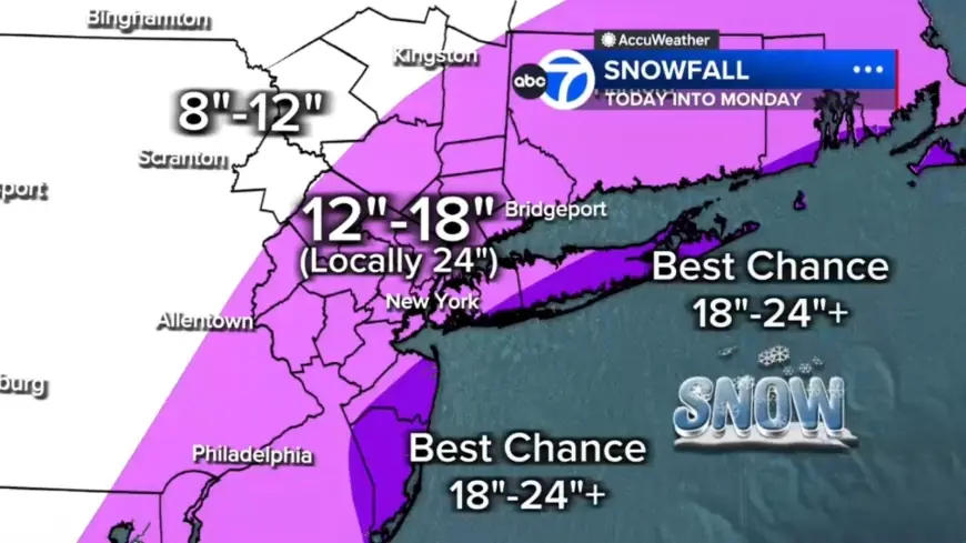
Forecasted snowfall amounts, bands and local contrasts
Widespread totals of 12 to 18 inches are expected across much of the region, while localized 18 to 24 inches or more are possible in eastern Long Island, the South Shore of Nassau County, parts of the Jersey Shore and even parts of New York City. Areas farther north and west—examples named in the forecast are Pike and Sullivan counties—are likely to receive under 12 inches where the storm's moisture will be less concentrated. Embedded snow bands could produce 2- to 3-inch-per-hour rates; any location stuck under one of these bands for several hours could quickly rack up totals near two feet or more.
Travel bans, transit shutdowns and thousands of flight disruptions
Travel across the Tri-State area has largely come to a standstill: vehicle bans are in place on roads across the region and the Long Island Rail Road was announced to shut down at 1 a. m. Thousands of U. S. flights have been disrupted by the storm, with more than 14, 000 flights affected as of 5: 30 p. m. ET on Sunday. About 8, 858 flights were canceled and another 5, 196 delayed. Jetblue, American Airlines, Delta, Southwest and United have announced they will waive change and cancellation fees ahead of the storm’s expected impact at major Northeast flight hubs. Heaviest snow is expected to begin Sunday night, with potential totals Sunday night into Monday topping 18–24 inches in New York City, Philadelphia and Boston.
Winds, coastal flooding and power risks
Forecasters outlined multiple wind scenarios: one forecast lists wind gusts of 45 to 60 mph, especially along the coast, with 70 mph gusts possible on the East End; the National Weather Service warned gusts up to 55 mph could create whiteout conditions that will make travel treacherous and potentially life-threatening. Strong winds combined with heavy, wet snow are expected to weigh down trees and wires and will likely result in scattered to numerous power outages. Coastal flooding is a major concern, particularly along the South Shore of Long Island and the Jersey Shore, where 2 to 3 feet of inundation is possible in vulnerable back-bay areas during high tide.
Weather images, states of emergency and human toll
More than 40 million Americans are under blizzard warnings as states of emergency declared in New York and New Jersey have been expanded to include Connecticut, Delaware, Massachusetts and Rhode Island. On the ground, maintenance crews cleared snow from the taxiway at LaGuardia Airport in New York City on Jan. 26, 2026, and travelers were photographed waiting for flights at John F. Kennedy International Airport in New York City on Nov. 18, 2025. Public-health warnings have followed heavy snow: a Tennessee man died after suffering a heart attack while shoveling snow, highlighting the acute risks of exertion in the storm.
Criteria, durations and when conditions are expected to ease
To qualify as a blizzard, conditions must include gusts over 35 mph, heavy snow and visibility under a quarter-mile for at least three hours; many parts of the region—including inland communities named in forecasts such as Sussex, Poughkeepsie and Newburgh—are likely to meet or exceed that threshold tonight into Monday. Some coastal communities may endure 12 to 16 consecutive hours of blizzard conditions. Snow is expected to continue through Monday morning, remaining heavy at times—especially from the city eastward—before beginning to ease midday and tapering to lighter bursts late afternoon and evening, though winds should remain strong well into Monday.