


Weather alert: Blizzard warnings expanded and snow totals increased for NYC and the Tri-State area
A major winter storm is rapidly intensifying off the mid-Atlantic coast, spreading heavy snow and wind across the Tri-State area and placing the entire region under a Blizzard Warning through 6 p. m. Monday ET. The fast-developing weather event has already disrupted flights and threatens heavy snow, damaging gusts and coastal inundation across a corridor from Virginia to New England.
Weather threats to travel and airports
Thousands of U. S. flights have been disrupted as the Northeast rushes to prepare for the blizzard expected to arrive Sunday. More than 14, 000 flights had been disrupted as of 5: 30 p. m. ET on Sunday, with about 8, 858 canceled and another 5, 196 delayed. Many flights were canceled Sunday at JFK, LaGuardia and Newark airports, and additional cancellations have already been scheduled for Monday. JetBlue, American Airlines, Delta, Southwest and United announced they would waive change and cancellation fees ahead of the storm at major hubs.
Blizzard Warning coverage across 29 counties and the broader corridor
The Tri-State area is entirely under a Blizzard Warning through 6 p. m. Monday ET, with all 29 counties in the viewing area covered — a sweep not seen since the Blizzard of 1996. The storm’s reach runs from Virginia to New England, and states of emergency declared in New York and New Jersey have been expanded to include Connecticut, Delaware, Massachusetts and Rhode Island. More than 40 million Americans are under blizzard warnings as the system tightens its grip.
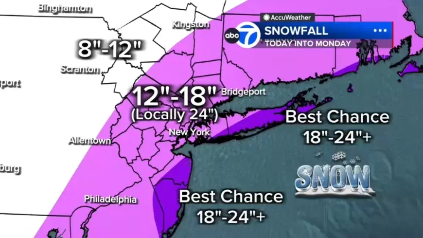
Snow totals and intense bands could produce 12 to 24+ inches
Forecasters expect widespread totals of 12 to 18 inches across much of the region, with localized 18 to 24-plus inches possible in eastern Long Island, the South Shore of Nassau County, parts of the Jersey Shore and even parts of New York City. The nor’easter is also forecast to bring 1 to more than 2 feet of snow to parts of the Northeast. Embedded snow bands could produce 2- to 3-inch-per-hour rates; any location stuck under one of those bands for several hours could quickly rack up totals near two feet or more. Two potential heavy bands appear most likely: one stretching from New Jersey into the Hudson Valley and another from Long Island down to the Jersey Shore. Areas farther north and west, for example Pike and Sullivan counties, are expected to see under 12 inches where the storm’s moisture will be less concentrated.
Blizzard conditions, wind gusts and coastal flooding risks
To qualify as a blizzard, conditions must include gusts over 35 mph, heavy snow and visibility under a quarter-mile for at least three hours. Many parts of the region — including inland communities such as Sussex, Poughkeepsie and Newburgh — are likely to meet or exceed that threshold tonight into Monday. Wind gusts of 45 to 60 mph are expected, especially along the coast, with 70 mph gusts possible on the East End. The National Weather Service warned the storm could bring wind gusts up to 55 mph, creating whiteout conditions that "will make travel treacherous and potentially life-threatening. " Forecasters also warned that "strong winds, combined with the weight of heavy, wet snow, will likely result in scattered to numerous power outages. " Power outages are also expected because heavy, wet snow can weigh down trees and wires.
Coastal inundation, timing and when conditions may ease
Coastal flooding is a major concern, particularly along the South Shore of Long Island and the Jersey Shore, where 2 to 3 feet of inundation is possible in vulnerable back-bay areas during high tide. The brunt of the storm is expected to unleash Sunday evening, continue overnight into Monday morning and linger throughout the day, with the most intense snowfall likely from midnight through daybreak Monday. Snow will continue through Monday morning, remaining heavy at times especially from the city eastward. Conditions are forecast to begin easing midday, tapering to lighter bursts late afternoon and evening, though winds are expected to remain strong well into Monday. Temperatures have dropped below freezing faster than expected and cold air locking in overnight will allow snow to accumulate quickly as roads that were wet and slushy this afternoon become snow-covered and travel deteriorates rapidly.