


Blizzard Warning Issued as Major East Coast Storm Expected Sunday, Monday
A blizzard warning is in effect for the entire Tri-State area through 6 p. m. Monday as a major winter storm rapidly intensifies just offshore. The alert matters now because the storm is forecast to bring heavy, potentially blizzard‑level snow, hurricane‑force gusts along the coast, and coastal flooding that could inundate vulnerable back‑bay areas by several feet during high tide.
Blizzard Warning Covers All 29 Counties
The Blizzard Warning encompasses all 29 counties in the viewing area and runs through 6 p. m. Monday. This is an exceptionally rare setup—an arrangement not seen since the Blizzard of 1996—and the system has been characterized broadly as a major East Coast storm expected Sunday and Monday. Eyewitness News urged viewers to check back for frequent live updates as conditions evolve.
Snow and Temperatures in New York City
Snow is already falling across New York City as temperatures have dropped below freezing faster than expected. That influx of cold air is forecast to lock in overnight, allowing snow to accumulate quickly as the storm ramps up. Roads described as wet and slushy this afternoon are expected to become snow‑covered by evening, and travel conditions are forecast to deteriorate rapidly tonight as the system develops into a full‑blown blizzard.
Wind, Coastal Flooding and Power Outage Risks
Overnight into Monday morning, wind gusts of 50 to 60 mph are expected, especially along the coast. Those gusts exceed the blizzard threshold of 35 mph used to define blizzard conditions when combined with heavy snow and visibility under a quarter‑mile for at least three hours. Heavy, wet snow could weigh down trees and wires, raising the risk of power outages. Coastal flooding is a separate and grave concern: the South Shore of Long Island and the Jersey Shore face the possibility of 2 to 3 feet of inundation in vulnerable back‑bay areas during high tide.
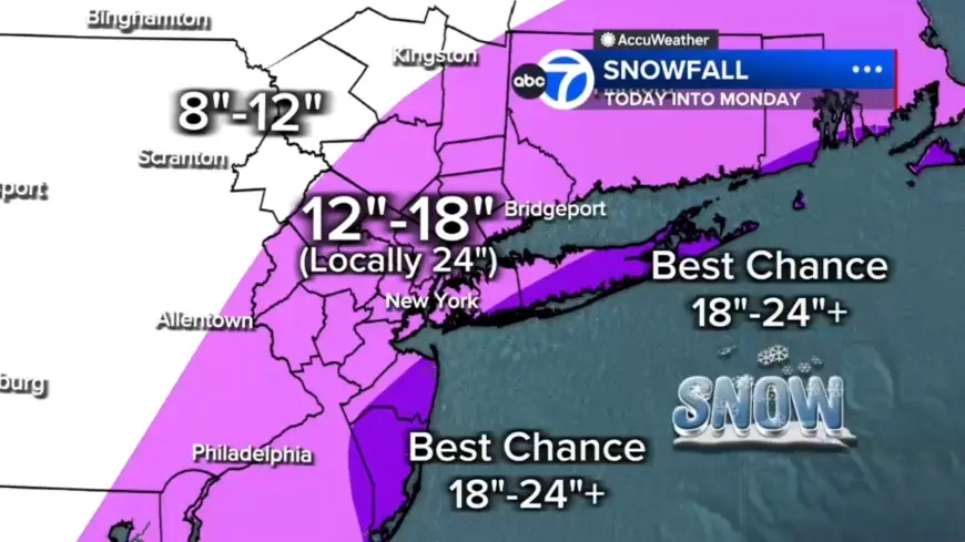
Snow Totals, Bands and Regional Differences from New Jersey to the Hudson Valley
Forecast models show widespread totals of 12 to 18 inches across much of the region, with localized amounts of 18 to 24-plus inches in eastern Long Island, the South Shore of Nassau County, and parts of the Jersey Shore. Farther north and west—examples cited include Pike and Sullivan counties—snow totals are expected to be under 12 inches because the storm's moisture will be less concentrated there.
Embedded snow bands are likely to develop and could produce 2 to 3 inches of snow per hour. Two potential bands appear most likely: one stretching from New Jersey into the Hudson Valley and another running from Long Island down to the Jersey Shore. Any location that remains under one of these bands for several hours could quickly rack up totals near two feet or more.
Transportation Actions, Timing and Expected Duration of Blizzard Conditions
Agencies have already moved to curb travel. NJ Transit will suspend rail service at 9 p. m.; the agency also announced that bus, light rail and Access Link services will be suspended beginning at 6 p. m. A travel ban will take effect at 9 p. m. Roads will transition from wet and slushy this afternoon to snow‑covered by evening, and travel is expected to deteriorate rapidly tonight as conditions box in and visibility falls.
Futurecast guidance indicates widespread heavy snow by early evening, with the most intense snowfall likely from midnight through daybreak Monday. Snow is expected to continue through Monday morning, remaining heavy at times—particularly from New York City eastward—and conditions will only begin easing by midday. Snow should taper to lighter bursts late Monday afternoon and evening, though winds are forecast to remain strong well into Monday. Some coastal communities may endure 12 to 16 consecutive hours of blizzard conditions. Many inland areas—specifically Sussex, Poughkeepsie and Newburgh—are likely to meet or exceed the blizzard criteria tonight into Monday.
Given the combination of high winds, heavy snow rates and coastal surges, officials warn of significant disruptions to travel, power and low‑lying coastal neighborhoods. Eyewitness News continues to offer live updates and frequent information as the situation unfolds.