


Orlando Weather: Near‑Record Heat Then a Major Cold Front Will Upend Weekend Plans
If you had outdoor plans, orlando weather is about to force quick adjustments: a blast of near‑record heat will make Saturday feel summery, then a strong cold front arrives by Sunday to cut daytime temperatures dramatically and bring blustery conditions into the start of the week. That flip reshuffles events, creates a brief window of light rain for some southern counties, and will still leave drought stress largely intact.
Orlando Weather consequences: plans, lawns and early‑week chill
Here’s the part that matters: outdoor events and weekend schedules face a two‑stage problem — intense warmth followed by a fast cooldown. Saturday’s sunshine and upper‑80s highs make for near‑ideal conditions for afternoon activities, but the front arriving Sunday morning promises a sudden pivot. Expect breezy, sharply colder air behind the front and daytime highs closer to the upper 50s by Monday; nights will dip into the 30s and 40s early in the week.
- Mini timeline
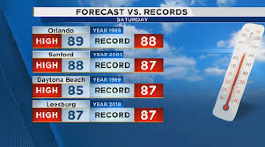
- Saturday: highs climb into the upper 80s with Orlando forecast to near 89 degrees, challenging a long‑standing record from 1989.
- Sunday morning: a strong cold front, currently across Central Texas, is due to approach Central Florida; spotty showers and downpours likely, especially after 7 a. m.
- Sunday afternoon into Monday: the front passes, breezy and sharply colder air moves in; Monday highs fall to near 58 degrees and early‑week lows drop into the 30s and 40s.
Schedule note: rainfall totals are expected to be light for most areas — under a quarter of an inch — with most rain focused on southern counties such as Osceola and Brevard.
What’s easy to miss is that this quick rain won’t be enough to erase drought stress. Several counties remain in the driest categories, and the limited expected precipitation is unlikely to change that short term.
Event details and local differences
Saturday will be dominated by abundant sunshine and highs into the mid to upper 80s across many coastal and inland communities; Sanford is likely to reach about 88 while other spots such as Daytona Beach and Leesburg will also be in the mid to upper 80s. That warmth edges near or just above historical marks in places where records stand.
The cold front is forecast to reach the region by Sunday morning. Showers and isolated downpours are possible after 7 a. m., but most locations should see less than a quarter‑inch of rain; the bulk of measurable precipitation looks aimed at southern counties. After the front moves through Sunday afternoon, winds will pick up and the air mass will be noticeably cooler—dropping daytime highs to around 58 degrees by Monday with overnight lows into the 30s and 40s when wind is factored in.
Those shifts mean a narrow window for watering, outdoor games and events Saturday, followed by a distinct change in conditions that will affect early workweek routines. If you’re wondering why this keeps coming up, it’s because the combination of near‑record warmth and a rapidly approaching front creates pronounced swings in temperature over just a day or two.
Local drought context remains important: maps show parts of Marion, Volusia and Flagler counties still in extreme drought, while the metro Orlando area is categorized from moderate to severe drought. The expected rainfall from the front is unlikely to make a meaningful dent in those classifications.
The real test will be how quickly the colder air settles in and whether any additional systems follow the front; for now, the core narrative is a hot, sunny Saturday turning into a blustery, much colder start to the week.