


Bloomington Tornado: Watch Extended Before Later Expiration as Damage Is Noted at Monroe County Airport
The Bloomington Tornado threat prompted an extended tornado watch for large parts of central Indiana and damage was noted in Bloomington at the Monroe County Airport and to some homes and businesses. The watch, which had been extended into the evening, was later listed as expired.
What happened and what’s new — Bloomington Tornado
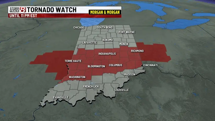
A tornado watch that had been expected to end at 9 p. m. Thursday in Indiana was extended to 11 p. m. The extended watch area included Indianapolis and a broad list of counties across central and southern Indiana. Parts of Kentucky and Illinois were also included in the watch area.
Tornado damage was noted in Bloomington at the Monroe County Airport and to some homes and businesses. In addition, Sullivan County Emergency Management noted damage to homes and cars from fallen trees. At least a dozen tornado warnings were issued in the state during the period covered by the watch.
The initial watch was issued shortly after noon Thursday. About mid- to late-afternoon, additional counties were added to the watch area: several counties were included shortly after 4: 20 p. m., and at about 6: 21 p. m. five counties including Indianapolis were added. Some counties along the Ohio River — specifically Clark, Floyd and Harrison — had been removed from the watch area as of 6: 21 p. m.
Behind the headline
The sequence in the coverage shows an evolving severe-weather situation across much of central Indiana: an initial watch issued shortly after midday, daytime expansions of the watch area as the afternoon progressed, and an evening extension of the watch window. The presence of multiple tornado warnings and damage notifications in separate communities underlines both the widespread nature of the threat and the operational response from local emergency management entities.
Key stakeholders named in the coverage include local emergency management offices that noted damage, officials responsible for the watch area, and communities within the expanded watch footprint — notably Bloomington and Indianapolis. Infrastructure that could be affected includes the Monroe County Airport and residential properties identified in the damage notes.
What we still don’t know
- Full extent of injuries, fatalities or the human toll from the tornado activity is not provided in the available text.
- Detailed damage assessments for the Monroe County Airport, homes and businesses in Bloomington are not included.
- Precise tornado paths, strength ratings, and exact timing of individual tornadoes are not stated.
- Whether airport operations were halted or the degree of infrastructural disruption at the airport is not specified.
- Whether subsequent local declarations or emergency orders were issued is not specified.
What happens next
- Continued assessments: Emergency management and local officials complete on-the-ground damage surveys to quantify impacts and prioritize response. Trigger: personnel completing assessments and releasing consolidated findings.
- Short-term recovery actions: Cleanup of fallen trees and debris around homes and vehicles proceeds, with local crews and residents restoring access. Trigger: availability of utility and municipal crews and road-clearance operations.
- Watch-and-warning cycle ends: With the watch later listed as expired, the immediate threat window closes, shifting focus from short-term protection to recovery. Trigger: official expiration or cancellation of watches and warnings.
- Further warnings or expansions: If conditions had continued to deteriorate, warnings or new watches could have been reissued for adjacent areas. Trigger: renewed severe-weather indicators during the same storm system.
Why it matters
The unfolding of the tornado watch and subsequent damage notes highlights tangible disruption for communities across central Indiana. The Monroe County Airport and nearby homes and businesses in Bloomington were directly affected, creating immediate needs for response and clean-up. Residents in a wide geographic area, including Indianapolis and multiple surrounding counties, experienced an elevated threat level as watches and warnings were issued and adjusted through the afternoon and evening.
Near-term implications include recovery and repair needs for damaged properties, assessment of airport infrastructure, and continued vigilance by emergency managers in counties that had been under the watch. The pattern of extensions and county additions during the day reflects the fluid nature of severe-weather situations and the operational decisions taken to protect communities while assessments proceed.